

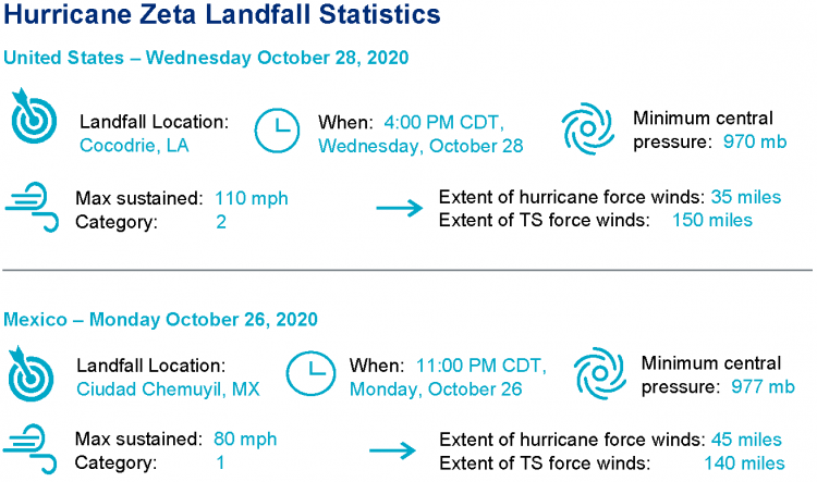
Hurricane Zeta made landfall the evening of October 28 around 4PM CDT, near Cocodrie, LA. According to National Hurricane Center (NHC) advisories, maximum sustained winds at landfall were 110 mph, a strong category-2 on the Saffir-Simpson Scale. The hurricane produced extensive wind impacts with downed trees and powerlines and variable property damage. Seawater inundation due to storm surge also affected areas from southeast Louisiana to the Florida Panhandle, with more severe impacts reported along the Mississippi Gulf Coast. Zeta crossed from Louisiana though the Appalachians while weakening to tropical storm status. The feature then cleared the Mid-Atlantic coast as a frontal system late October 29. Widespread reports of downed trees and powerlines with resulting power outages, along with variable property damage were inflicted from the northern Gulf States to the Mid-Atlantic as the storm crossed the region. Hurricane Zeta made its first landfall on the Yucatan Peninsula, near Ciudad Chemuyil, Mexico, around 11PM CDT October 26. The storm made landfall as a category-1 hurricane with maximum sustained winds of 80 mph.
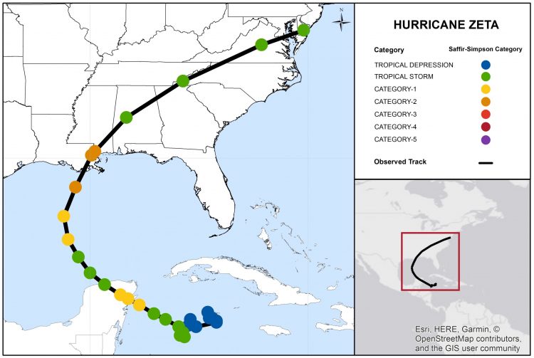
Hurricane Zeta Track and Position Reports. Source: NOAA/NHC.
This report comprises the following sections
- Regional Impacts
- Notable Impacts by Sector
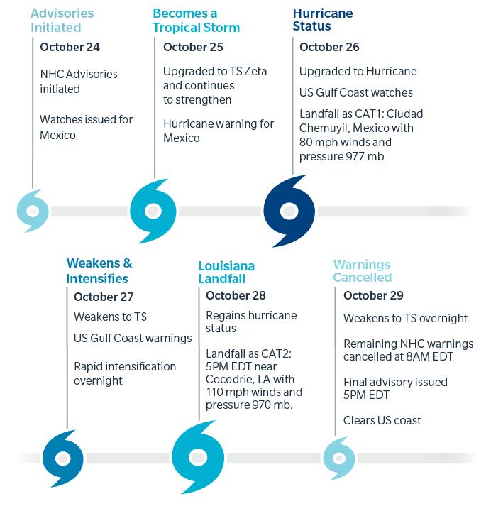
- Key Dates in Timeline of Hurricane Zeta
- Physical Discussion
- Peak Meteorological Statistics
Regional Impacts
Impacts Discussion
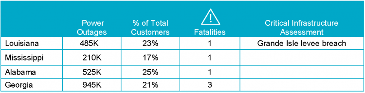
At least six fatalities occurred as a result of Hurricane Zeta, according to media reports. The hurricane produced severe wind damage in immediate coastal areas of southeast Louisiana and Mississippi, along with seawater inundation due to storm surge in excess of nine feet. As Zeta crossed from Louisiana and Mississippi to the Mid-Atlantic, it also produced an extensive area of wind impacts with downed trees and powerlines, with resulting power outages, and variable property damage. At least 2.6 million homes and businesses were without power, according to media reports. Hundreds of schools cancelled classes or opened late as a result of the storm. Earlier in the week, Zeta produced downed trees and powerlines with resulting power outages, and variable structural damage, for portions of the Yucatan Peninsula.
Louisiana
In New Orleans, media reports indicate at least one fatality, where a 55-year-old man was electrocuted by a downed power line. Another person was injured after a roof collapsed on a building. As the eyewall of Hurricane Zeta brushed the New Orleans area, it left at least 200 downed trees and powerlines with resulting power outages affecting most of the City. Significant wind damage was also evident for portions of the New Orleans area. Officials indicate that a turbine for the drainage pump system broke prior to Zeta, and while enough power was available to maintain pump activity, there was little excess power available should other turbines fail. Meanwhile the Lake Pontchartrain Causeway Bridge was closed. Meanwhile in coastal Louisiana, reports indicate flipped trailers and a destroyed gas station along with downed trees and powerlines with resulting power outages. Extensive property damage due to wind has also been reported. A person was hospitalized with minor injuries after a structure collapsed. Extensive roof damage was reported in Saint Bernard Parish. Seawater inundation due to storm surge also flooded coastal roadways and property, including a marine laboratory that was inundated. In Lafitte, boats broke loose and struck a bridge. At least 94 percent were without power in Plaquemines Parish, where the Governor reported extensive blackouts with extensive structural damage to businesses, homes and electrical infrastructure including downed power poles. In Lafourche Parish, at least four buildings collapsed in the southern portion of the Parish. In Jefferson Parish, about 25 people had to be evacuated as part of an apartment building collapsed near Gretna; one person was injured. Meanwhile in Grand Isle, severe to complete roof damage was reported to large homes in the area. Downed power poles and wires were also reported along with a crumpled gas station canopy. The Grand Isle Levee also was breached in three spots, following initial extensive damage from Tropical Storm Cristobal earlier in the year.
Mississippi
A fatality occurred when an Alabama man drowned while taking video of the storm at a Biloxi marina, according to media reports. Multiple injuries were also reported across Harrison County. Seawater inundation due to storm surge reached five feet around a Biloxi casino, where several parked cars were inundated by seawater. Meanwhile in Bay Saint Louis, U.S. Highway 90 was covered by seawater, and boats were lifted onto the highway. Significant wind damage is also evident in the Bay Saint Louis area. On Interstate 10 near Bay Saint Louis, multiple trucks were knocked over. Downed trees and home damage were also reported in Forrest and Lamar Counties.
Alabama
In Mobile, seawater inundation was reported as a result of storm surge. Meanwhile the City of Citronelle suffered major damage, according to officials, and two schools were damaged in Autauga County. Many roads were impassable in Greenville, due to downed trees and powerlines. In Elmore County, county-maintained roads and bridges were declared by officials as impassable. Downed trees and blocked roads were also reported in Chilton County. At least 489,000 power outages were reported across the state.
Georgia
At least three fatalities were reported by media, including one from a downed tree on a mobile home in Cherokee County. In the Atlanta area, major power failures were reported by media. Downed trees and powerlines also blocked roadways, and traffic signals were without power. Downed trees also blocked lanes on Interstates in the area. Meanwhile in Marietta, traffic lights were out and roadways were blocked by light wind-driven debris including tree limbs and campaign signs. An Atlanta man was hospitalized with minor injuries after a tree fell onto his home. Downed trees blocked dozens of roadways, including Interstate 20 in Fulton and DeKalb Counties, and Interstate 985 in Gwinnett County. Several school districts in the state moved classes fully online, or cancelled classes altogether for Thursday. Meanwhile at least fifteen counties delayed opening early voting sites, including Douglas County due to power outages. At least 755,000 customers were without power earlier today, down from a peak of more than 1 million.
Carolinas
Hundreds of trees were downed across North and South Carolina. In Asheville, North Carolina, flooding forced residents of a mobile home park to evacuate as floodwaters exceeded two feet. Flooding was also reported in Lenoir in Caldwell County. At least 50 reports of downed trees affected Greenville, South Carolina with blocked roadways. In Spartanburg County, downed trees and considerable damage were reported in the Town of Landrum; Highway 14 and Interstate 26 were blocked by downed trees. York County also had extensive reports of downed trees and blocked roadways. Meanwhile in Statesville, North Carolina, a downed tree hit a mail truck. Power outages affected at least 500,000 homes and businesses, according to media reports.
Mexico
Hurricane Zeta produced downed trees and powerlines as it crossed the Yucatan Peninsula. Power outages in Mexico affected at least 300,000 people, according to media reports. Variable property damage was also reported, in part driven by remnant debris from Hurricane Delta driven by strong winds. In the meantime, residents were evacuated in Banco Chinchorro, Othon P. Blanco, Punta Allen, Tulum, Maria Elena Island and Punta Herrero. Nearly 60,000 tourists were estimated to be in Quintana Roo at the time, and were afforded 71 different shelters, while most remained in their hotels. Reports indicate that 817 people and five pets were taken in across shelters across the state.
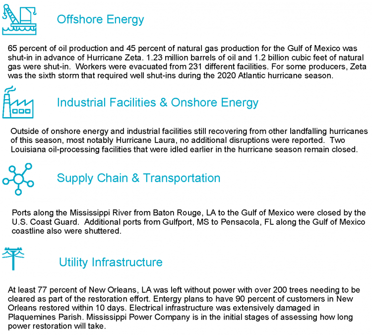
Notable Impacts By Sector

Hurricane Zeta Timeline
Physical Discussion
The general timeline of Hurricane Zeta is shown above, following advisories of the National Hurricane Center. Key aspects defining Hurricane Zeta follow below.
1) Historical Significance:
a) Sixth hurricane landfall on the Continental U.S. in 2020, tying 1985 and 1886 for the known historical record.
b) Eleventh named storm to make landfall on the Continental U.S., surpassing previous known records.
c) Fifth named storm to make landfall in Louisiana, the first time over the known historical record since 1851.
d) Second Greek alphabet named storm to make landfall on the Continental U.S.
e) Hurricane Zeta was the 27th named storm in the Atlantic Basin for the 2020 season, the earliest of the known historical record since 1851. Zeta was named by the NHC on October 25, 2020, in contrast to 2005 where Tropical Storm Zeta was named on December 30, 2005.
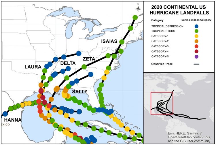
Continental U.S. Hurricane Landfalls as of October 29, 2020. Source: NOAA/NHC.
2) Yet Another Case of Rapid Intensification:
Zeta underwent a period of rapid intensification on approach to the northern Gulf Coast, before final landfall as a category-2 hurricane. Cooler sea-surface temperatures and increasing wind shear acted to suppress development. However, good storm ventilation was able to overcome these suppressive factors and strengthen the storm. The storm ventilation occurred as flight-level wind patterns pulled air from the top of the hurricane allowing it to “breathe”, ahead of a robust disturbance advancing from the southwestern U.S. Similar mechanics enabled aggressive strengthening prior to landfall for both Hurricane MIchael (2018) and Hurricane Camille (1969). Seven hurricanes in 2020 have undergone rapid intensification. While well above normal, the count is below that of 1955 and 2010, and also the highest number of rapid intensification events seen in a single season in 1995, featuring 10 different storms undergoing rapid intensification.
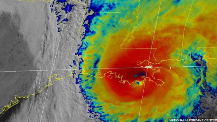
Satellite Image (Infrared) of Hurricane Zeta at Landfall. Source: NOAA.
3) Storm surge:
The increasing footprint of Zeta, together with increased strength and prolonged southerly flow, caused a storm surge well in excess of 9 feet along portions of the Mississippi Gulf Coast. Storm surge affected areas from southeast Louisiana to western Florida, with impacts also reported on Lake Pontchartrain.
Peak Meteorological Statistics
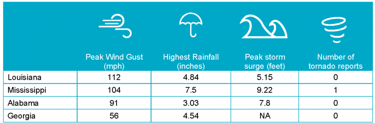
Note: Storm surge elevation are all above NAVD88 datum. Highest rainfall reported by AWOS/AFOS weather stations in a 24- hour period. Sources: NOAA, CERA, Guy Carpenter.[/caption] Sources: Reuters, The Weather Channel, Associated Press, U.S. National Hurricane Center, U.S. National Weather Service, Energy News Room, Wall Street Journal, USA Today, Mexico News Daily, Riviera Maya News. Lead Image Source: College of DuPage.