

Hurricane Delta has regained category-2 strength following landfall yesterday along the Yucatan Peninsula in Mexico. Despite losing a significant amount of strength since Tuesday, Delta is currently a well organized hurricane packing winds of 100 mph and is expected to gradually gain intensity over the next 24 hours due to favorable environmental conditions of warm water, high moisture, and low shear. Delta is forecast to regain major hurricane status by tonight followed by slight weakening or leveling off ahead of landfall late Friday. Tropical storm conditions are expected to begin Friday morning along the northern Gulf Coast. Significant storm surge, damaging winds, and flooding are likely throughout the warning area as Delta takes aim at the same area ravaged by Hurricane Laura just six weeks ago.
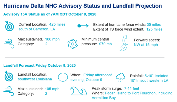
- Turn to the north: Track forecasts for Delta have remained relatively stable and confidence in a landfall along the Louisiana coastline is growing. Delta is expected to take a turn to the north tonight and eventually to the northeast by tomorrow night bringing the core of the hurricane to the Louisiana coastline Friday afternoon or evening.
- Intensity forecast: Delta is a category-2 storm as of this morning, and favorable environmental conditions will be conducive for some gradual strengthening over the next day or so. Recent data from the storm suggests that the core of Hurricane Delta is continuing to improve and forecast guidance calls for Delta to regain major hurricane strength later today. Before landfall on Friday, Delta is expected to level off or slightly weaken due to cooler waters and less favorable atmospheric conditions.
- Growth in size: Hurricane Delta is gradually growing in size and is expected to continue to do so as it traverses the Gulf of Mexico today and tomorrow. An increase in the overall size of the storm will result in a broader area experiencing both hurricane and tropical storm force winds upon landfall.
- Take two for Coastal Louisiana: Hurricane warnings extend from the Texas/Louisiana border to Morgan City, LA, putting nearly the identical swath of coastline under a hurricane warning in just six weeks. Damaging, major hurricane force winds are likely within the warning area with the potential to render widespread property damage, especially in areas impacted by Hurricane Laura. Impacts will be most severe along and to the right of the storm track.
- Rainfall and flooding: 5 to 10 inches of rainfall can be expected through the early half of the weekend for much of western Louisiana, with isolated amounts of 15 inches in southwest and south central portions of the state. Significant flash, urban, and isolated riverine flooding is possible as a result. Delta will bring 3-6 inches and 1-3 inches to parts of the lower Mississippi Valley and Ohio Valley, respectively, as it moves northeast this weekend.
- Storm Surge: The growing size of the storm together with prolonged duration of category-2 or 3 winds will produce a storm surge that could exceed 5-10 feet in localized areas, according to the NHC. This will render property damage to immediate coastal areas and adjacent waterways due to seawater inundation, water velocity damage and waterborne debris, with wave bettering impacts possible for immediate coastal areas previously affected by Hurricane Laura.
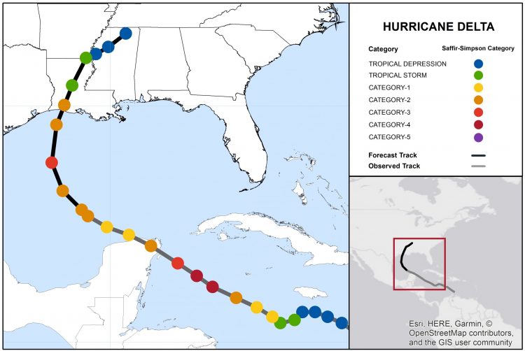
Hurricane Delta Track and Forecast. Source: NOAA/NHC.
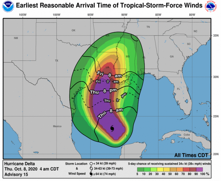
Earliest expectation of onset of tropical storm force winds. Source: NHC/NOAA.
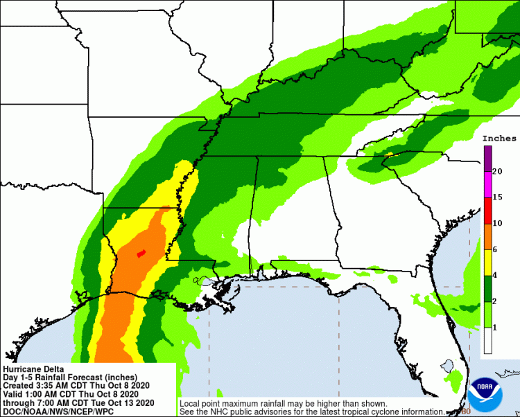
Five day rainfall forecast through 7AM CDT Tuesday, October 13. Source: NOAA/WPC.
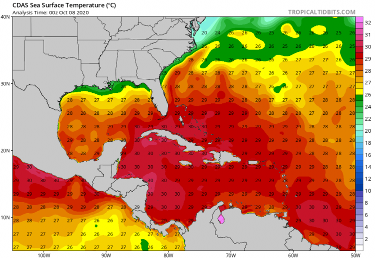
Sea Surface Temperatures for the Western Atlantic, showing a swath of cooler water adjacent to the Central Gulf Coast. Source: Tropical Tidbits.
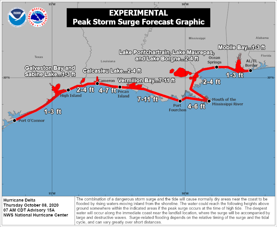
NHC Experimental Peak Storm Surge Forecast for Delta. Source: NOAA/NHC.
Updates and Useful Links
Email alerts for Weather Sentinel and CAT-i reports are available on a subscription basis at the GC Preference Center here.
Daily, global tropical cyclone alerts are also available on a subscription basis here.
U.S. National Hurricane Center
Official statements from the NHC and U.S. National Weather Service, and those of emergency management agencies supersede this update, and should be closely monitored concerning matters of personal safety.