

Key Headlines:
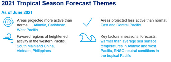
- Active Atlantic anticipated: Across all forecast entities spanning academia, government and private sector, there is unanimous consent the 2021 Atlantic hurricane season will feature average to above average named storms, hurricanes, major hurricanes and storm days.
- Factors driving active Atlantic forecast: Factors in play include above-average sea-surface temperatures in the Atlantic and west Pacific regions, as well as a forecasted transition from La Niña to ENSO-Neutral conditions.
- Ramifications for Atlantic basin landfalls: The ratio of hurricane landfalls to basin activity varies considerably from year to year, and depends strongly on steering currents. Weather prediction for any event generally loses skill beyond a 7-10 day forecast lead.
- West Pacific typhoon expectations: Through the Guy Carpenter Asia-Pacific Climate Impact Centre relationship with the City University of Hong Kong, the 2021 West Pacific forecast indicates above average activity. However, the landfalling numbers across the region vary, with above average activity most likely for South Mainland China and Vietnam.
Range of Atlantic Forecasts
Seasonal outlooks for the 2021 North Atlantic Hurricane season are shown below, including observed averages, from:
- National Oceanic and Atmospheric Administration (NOAA)
- UK Met Office (UKMet)
- Colorado State University (CSU)
- The Weather Company (TWC)
The 1950-2020 average represents a longer-term period where hurricane detection in the Atlantic Basin includes overflight data from the late 1940s, and then satellite data from about 1970 onwards. The 1995-2020 average is reflective of the current active period of hurricane activity that began around 1995.
Seasonal outlooks for the 2021 North Atlantic Hurricane season with observed averages.
Sources: NOAA, UK Met Office, Colorado State University, The Weather Company
Key Factors Driving Forecast
- Above average Atlantic & West Pacific sea-surface temperatures: Sea-surface temperatures are trending above average for much of the Atlantic Main Development Region as well as the western Pacific basin. With all-else equal, this would be associated with elevated tropical activity in the Basin. Sea-surface temperatures are trending below average along portions of the west-Atlantic, Caribbean and Northern Gulf of Mexico, and if this trend persists it could mute the potential for sudden development “in close” to these regions as compared to prior years.
- ENSO neutral conditions: The tropical eastern Pacific was cooler than average over last winter, consistent with a moderate to strong La Niña. This has since weakened to ENSO-neutral conditions. Absent an improbably development of El Niño conditions which would increase wind shear, limiting tropical development, ENSO will not limit storm development this season.

Source: Tropicaltidbits.com Probability of La Niña (blue), El Niño (red) and ENSO-Neutral (grey) conditions through winter 2022, with ENSO-Neutral most probable for the August-October period. Source: NOAA/CPC, Columbia University
 Seasonal forecasts issued for basins monitored by the National Hurricane Center and Central Pacific Hurricane Center. Source: NOAA
Impact of landfall activity across the West Pacific basin when ENSO neutral conditions are present.
Source: Guy Carpenter / City University of Hong Kong.
Additional links of interest:
Colorado State Seasonal Hurricane Forecasts
NOAA Seasonal Hurricane Outlook
Guy Carpenter Asia-Pacific Climate Impact Centre
Barcelona Supercomputing Center Catalog of Seasonal Atlantic Forecasts