
Live Event: Ida Hits Eastern U.S. with Extreme Flooding and Severe Thunderstorm Activity
Key Ida Headlines
- Exceptional Mid-Atlantic Flooding: Both in terms of hourly rainfall rates as well as daily rainfall totals, Ida brought extreme, and in some cities, record setting rainfall to the Mid-Atlantic yesterday. Wide swaths of Pennsylvania, New Jersey, New York and Connecticut saw rainfall totals exceed 200 year return periods for daily rainfall totals (annual exceedance less than 0.5%).
- Tornado Outbreak: Multiple reports of tornadic activity in the densely populated areas of Annapolis, MD, Philadelphia, PA and Gloucester County, NJ are being surveyed today by the National Weather Service. Initial damage reports the potential for multiple EF2 or 3 tornadoes, also a rare occurrence across the region. Tornado activity for portions of Maryland, southeast Pennsylvania, New Jersey and New York transpired under conditions of abundant moisture, instability from daytime heating and some cloud breaks, and wind shear from the circulation of Ida.
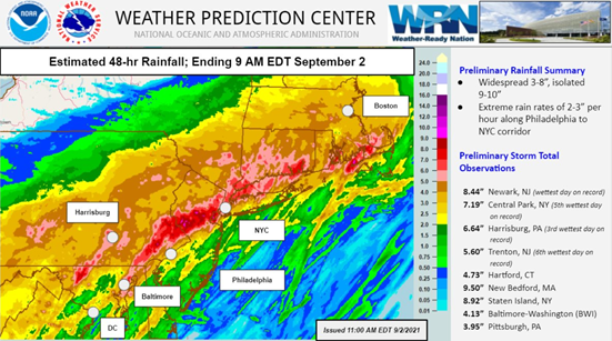
48 hour rainfall totals ending 9AM EDT, Thursday September 2, 2021, along with record setting statistics.
Source: NOAA Weather Prediction Center.
Historic Mid-Atlantic Flooding
- Antecedent Conditions: Saturated soils across the Mid-Atlantic and Northeast U.S. region prior to Ida were already in place. Heavy rainfall most recently Tropical Storm Fred and Henri, and longer term Elsa and Claudette resulted in nearly all rainfall going to runoff rather than absorbed by soils.
- Historic Rainfall Rates: Both Newark, NJ and New York City, NY registered their highest one hour rainfall total in city history. For New York City, this eclipses the prior all-time record set 10 days ago during the landfall of Tropical Storm Henri. Additionally, Tropical Storm Elsa registered the 10th highest hourly rainfall rate in city history in July 2021. An addendum with more details on this historical rainfall totals is available at this LINK.
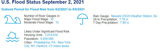
- Record River Flooding: With 30 different river gauge reports of major flooding, multiple rivers in the Mid-Atlantic are seeing top five, if not all-time high river crests. Rivers with all-time crests include: Raritan River at Manville, NJ, Schuykill River at Norristown, PA, Stony Brook at Princeton, NJ and the Brandywine Creek at Wilmington, DE.
- Infrastructure Disruptions: Rail service across the Mid-Atlantic and Northeast is largely halted including Amtrak, NJ Transit, MTA, Metro North Railroad and SEPTA announcing service closures due to electricity issues and track washouts. Flooding in terminal B at Newark Airport prompted closure of the airport for a period on Wednesday night. Widespread road closures across the region due to flash flooding are still transpiring on Thursday. Power outages across the region tally slightly less than 100,000 customers Thursday afternoon.
Tornado Activity
- Gloucester County, NJ: Multiple media outlets reported an apparent wedge tornado rendering significant damage to portions of Mullica Hill, NJ, with severe to complete damage to roof and exterior walls for certain wood frame structures while completely flattening other structures. NWS damage assessment efforts are scheduled for Thursday to confirm and rate this tornado. Seven other potential tornadoes in the Philadelphia metropolitan region are also being surveyed today, pending accessibility due to flooding and road closures.
- Annapolis, MD: An additional tornado impacted Anne Arundel County, MD with multiple reports of extensive commercial and residential property damage. Storm survey teams are also assessing the magnitude of damage on Thursday.
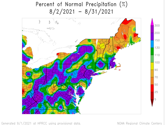
30 day rainfall totals across the Mid-Atlantic and southern New England were running 50-100% above average due to the influence of multiple heavy precipitation events associated with landfalling tropical storms Henri, Fred, and earlier in the season Elsa and Claudette.
Source: High Plains Regional Climate Center.
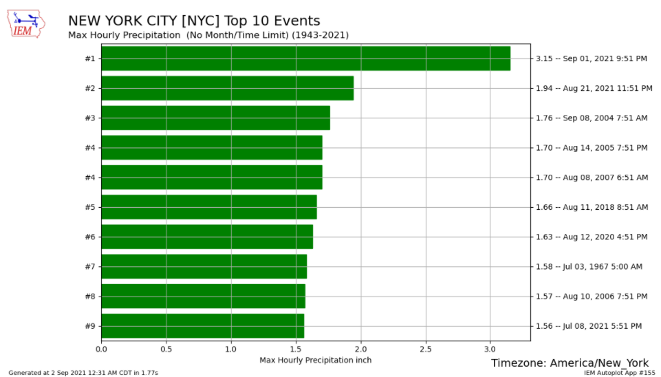
Three of the top ten hourly rainfall records at New York City (Central Park), NY have transpired this year. Ida on Wednesday September 1st tallying 3.15" in an hour far exceeded the prior record set 10 days prior with Tropical Storm Henri of 1.94".
Source: Iowa Mesonet.
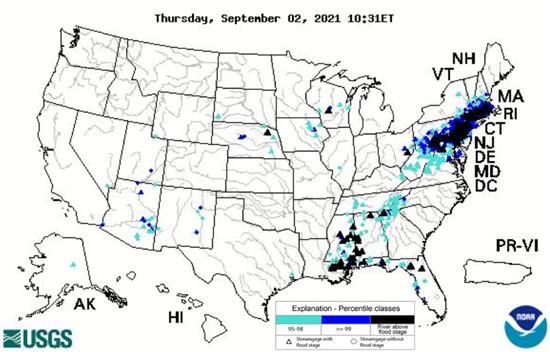
USGS river gauges under high flow as of September 2, 2021.
Source: USGS.
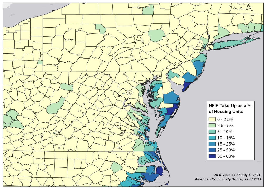
NFIP take-up rate by county. Outside coastal counties, penetration is generally less than 2.5%.
Source: FEMA, ACS, Guy Carpenter.
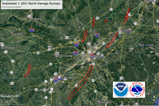
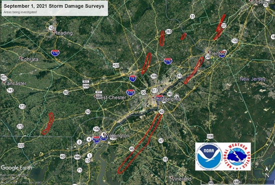
Eight different storm surveys being conducted by National Weather Service Philadelphia to confirm tornado activity and assess Fujita scale rating.
Source: National Weather Service Philadelphia.
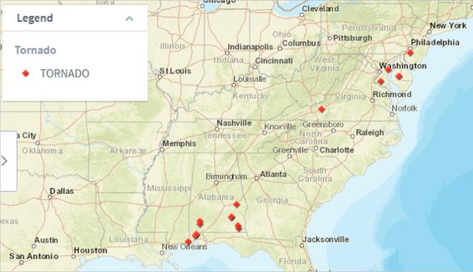
Tornado reports associated with Ida's track across the eastern United States.
Source: Storm Prediction Center / Guy Carpenter.
Additional links of interest:
NOAA Weather Prediction Center list of wind and rain reports of Ida
NOAA Advanced Hydrological Prediction Service