Key Headlines
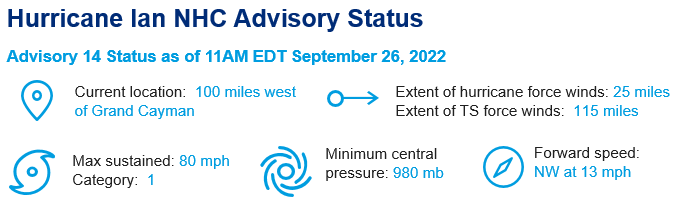
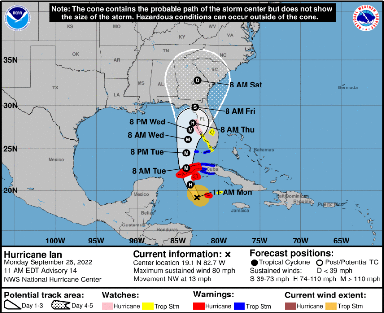
- High Confidence in the Two Day Forecast, Rapid Intensification Expected: Ian was upgraded to hurricane status by the NHC at 5AM EDT this morning and is expected to undergo a period of rapid intensification to major hurricane status as it makes a turn into the southeastern Gulf of Mexico through Tuesday.
- Model Guidance Spread Still More than Desired Wednesday through Friday: The forecast track from Tuesday remains one of low confidence with a range of scenarios from the western Florida Panhandle to the southwest Florida Peninsula. While the track moving near parallel to the coast reduces skill in the anticipated landfall, Ian will expand in size with a reduction in forward speed. As a result, most of the Florida peninsula will see a prolonged period of hurricane winds, storm surge and excessive rainfall. Accounting for these factors, the NHC best forecast takes Ian to major hurricane status by Tuesday morning, and category-4 status by Tuesday afternoon with a period of rapid intensification. Later in the period, Ian should encounter increased wind shear which should cause the storm to weaken, but also cause considerable expansion in size, before final approach to the Florida Peninsula.
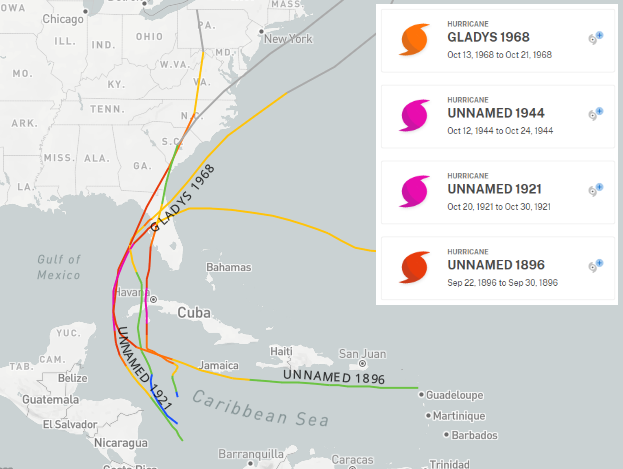
- Historic Analogs: If Ian does make landfall along the west-central Florida Peninsula, there are four events in history that are similar in track and possible intensity: 1896 (category-3), 1921 (category-3), 1944 (category-2) and Hurricane Gladys 1958 (category-2). The simulated losses across these four events ranges from minimal loss in Gladys, to a range of USD 15 billion to USD 35 billion across the other three hurricanes. If Ian verifies to the western side of model guidance, a panhandle landfall at a lower intensity would be more likely, with a range of historic analogs suggesting reasonable worse case loss scenarios in the low single digit billions.
What is Needed to Gain Confidence in the Forecast:
- Model spread: Ian is expected to make close approach to the Cayman Islands and Cuba as it makes a gradual turn to the north over the next 24 hours. Ian will enter the southeastern Gulf of Mexico on Tuesday before reaching status as a category-4 hurricane. Ian should then approach the Florida Gulf Coast, however model track guidance still shows considerable spread with a range of scenarios from the western Florida Panhandle to the Florida Keys. Unfortunately, the track forecast remains a lower confidence outlook than desired with a lead time of less than five days.
- Factors driving the model divergence: The factors in play include the subtropical ridge to the northeast of Ian, and an upper-level depression extending southward from the mainland. The timing, strength and placement of these features is critical to the track and the forward speed of Ian. Accounting for these factors, the NHC best forecast takes Ian on approach to the Florida Peninsula late Wednesday into Thursday morning, with onset of conditions as early as Tuesday morning for the Florida Keys, and Tuesday evening for Tampa/St. Petersburg area.
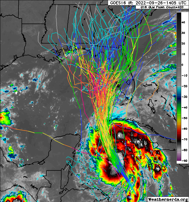
- Intensity forecast is higher than average confidence: Ian is now beginning to show signs of increased activity and improved structure with a rapidly decreasing central pressure. Ian should continue to move through a moist environment of reduced wind shear and very warm waters, with ventilation from upper-level wind patterns to enhance strengthening. Accounting for these factors, the NHC best forecast takes Ian to major hurricane status by Tuesday morning, and category-4 status by Tuesday afternoon with a period of rapid intensification. Later in the period, Ian should encounter increased wind shear which should cause the storm to weaken, but also cause considerable expansion in size, before final approach to the Florida Peninsula.
Impacts
- Hurricane, tropical storm and storm surge watches and warnings are now active for areas under threat in the Caribbean and portions of Florida. Specifics will evolve and can be found at www.nhc.noaa.gov. Conditions of hurricane to major hurricane wind conditions can be expected for areas under threat. Substantial damage to property and infrastructure can be expected in areas affected by major hurricane conditions, especially for those areas near and to the right of the core of the storm. Downed trees and powerlines are probable along with resulting power outages for widespread areas well-away from the storm.
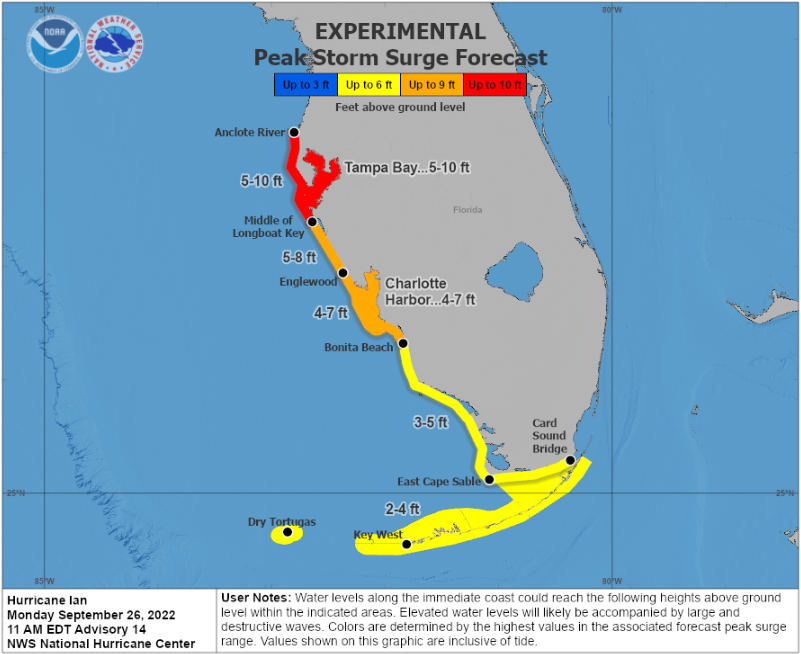
- Significant storm surge event increasingly likely: Ian will be a large storm with reduced forward speed as it approaches the Florida Peninsula and this will result in prolonged and possibly enhanced hazards, especially concerning storm surge and rainfall amounts. The NHC is expecting a storm surge as high as 5 to 10 feet for portions of the Florida Peninsula for areas including Tampa Bay, which will cause seawater inundation to both property and infrastructure for the coast and connected waterways, along with wave-battering for immediate coastal areas.
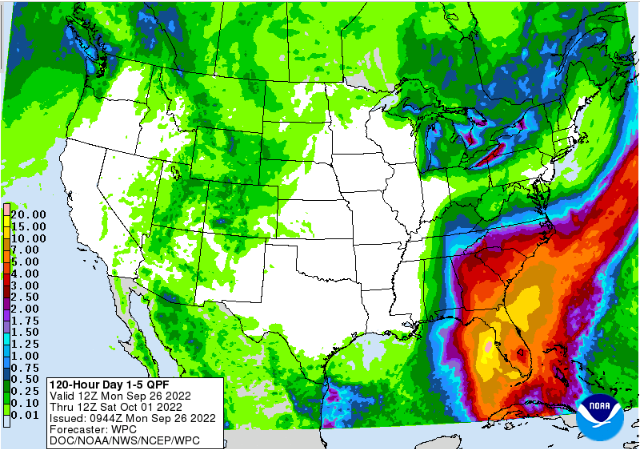
- Excessive rainfall amounts of 8-10 inches and local amounts to 15 inches are possible in portions of Central Florida which will contribute to flooding and flash-flooding. Specifics will evolve depending on the still-uncertain track of the storm, but conditions will extend well-away from the center of the storm and over prolonged duration given current guidance.