Header

Live Event: TS Fiona, What to Look for This Weekend

Hero image

Questions to Gain Clarity on Over the Weekend

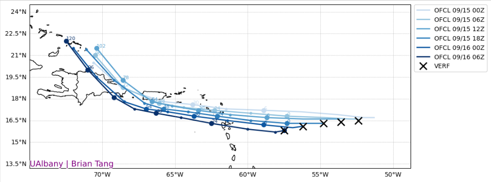
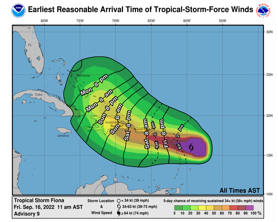
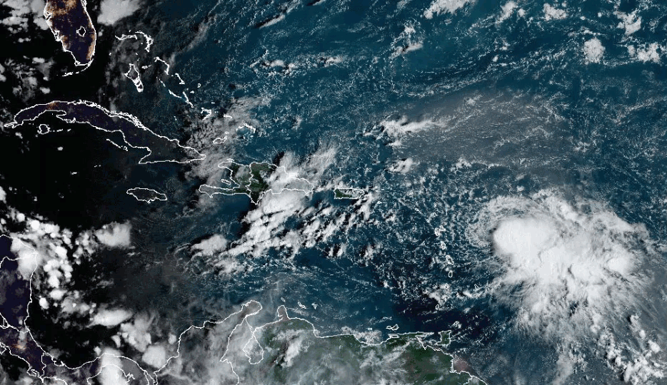
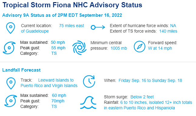
  • Fiona's Impact to the Caribbean? Tropical Storm Fiona drifted slightly south of yesterday's track forecasts through Friday morning but now appears the center of circulation will likely move westward between Guadeloupe and St Kitts this evening. Subsequently, the storm could start to move northward anywhere between Puerto Rico and Dominican Republic. Tropical warnings and watches have been issued for Puerto Rico and Dominican Republic respectively. The largest concern for the Caribbean islands is excessive rainfall that could result in mudslides and flooding, particularly in mountainous regions.
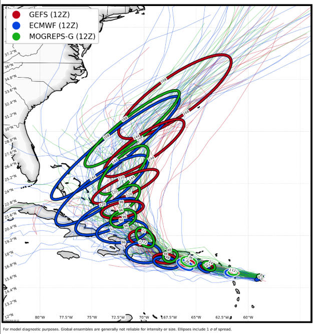
  • When will Fiona Make a Turn to the North? Thereafter, weather model guidance indicates Fiona will turn north over the eastern Hispaniola Monday morning. Due to the mountainous terrain of central Hispaniola, the circulation center could be significantly disrupted due to land interaction. However, the southern track affords Fiona an opportunity to track over very warm ocean temperatures, potentially partially offsetting some weakening due to land interaction.
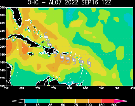
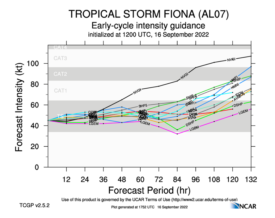
  • How will Fiona Emerge and Recover in the southwest Atlantic?  Once the track out of the Caribbean is known, Fiona will be transiting some of the highest levels of ocean heat content of the southwest Atlantic through Wednesday while approaching or moving over the Turks & Caicos and Bahamas. Atmospheric conditions look conducive for strengthening as wind shear diminishes and upper level conditions also favor intensification. There is increasing concern of potential hurricane impacts to portions of these islands early next week.
  • Beyond Five Days, Are Further Land Impacts Possible? This is a question that will have some clarity after observing several factors over the weekend:
    • North America Jet Stream Pattern: By the middle of next week, a trough of low pressure is forecast to be situated across eastern Canada.  The strength and southern extent of the trough will be a significant factor determining Fiona's track in the western Atlantic next week.
    • Recurving West Pacific Typhoons: Super Typhoon Namandol is projected to hit southern Japan early next week and rapidly move northward, just on the heels of Typhoon Merbok which strengthened into a strong low pressure over Alaska. These two storms are increasing weather model uncertainty for the jet stream position and strength late next week. By early next week, weather models should have a better handle on the jet stream impact of these two typhoons.
Verification of the NHC forecast since Thursday morning. Unusually large track forecast errors within 12-24 hours have transpired with Fiona verifying further southwest than anticipated. This has reduced some direct impacts across the Greater Antilles through Puerto Rico. Source: Dr. Brian Tang, UAlbany.
Ocean heat content, indicating the amount of fuel available for storm strengthening. Fiona's track south of the Greater Antilles until the Dominican Republic results in opportunity for further organization before crossing Hispaniola.  Source: RSMAS / University of Miami.
Ocean heat content, indicating the amount of fuel available for storm strengthening. Fiona's track south of the Greater Antilles until the Dominican Republic results in opportunity for further organization before crossing Hispaniola. Source: RSMAS / University of Miami.
Long range track forecast for multiple model ensembles through Wednesday September 21. Each oval shows in 24 hour increments the middle two-thirds of each model ensemble. The stretched ovals indicate a wide range of outcomes regarding timing an speed of recurvature after Sunday.  Also, the blue ovals, representing the European model, are further west than the MOGREPS (UK Met Office) and GFS (American) models. Source: CIRA/Colorado State.
Long range track forecast for multiple model ensembles through Wednesday September 21. Each oval shows in 24 hour increments the middle two-thirds of each model ensemble. The stretched ovals indicate a wide range of outcomes regarding timing an speed of recurvature after Sunday. Also, the blue ovals, representing the European model, are further west than the MOGREPS (UK Met Office) and GFS (American) models. Source: CIRA/Colorado State.
Model intensity forecasts for Fiona through Wednesday September 21st, showing likely intensification while tracking across the southwestern Atlantic.  Source: UCAR.
Model intensity forecasts for Fiona through Wednesday September 21st, showing likely intensification while tracking across the southwestern Atlantic. Source: UCAR.
Earliest reasonable timing of tropical storm force winds, along with shaded probabilities of exceeding 39 mph sustained winds over a five day period.  Source: NOAA/NHC.
Earliest reasonable timing of tropical storm force winds, along with shaded probabilities of exceeding 39 mph sustained winds over a five day period. Source: NOAA/NHC.
Footer