

Key Headlines
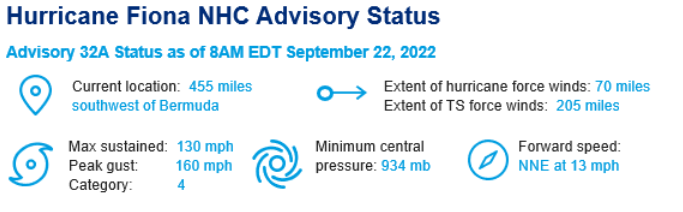
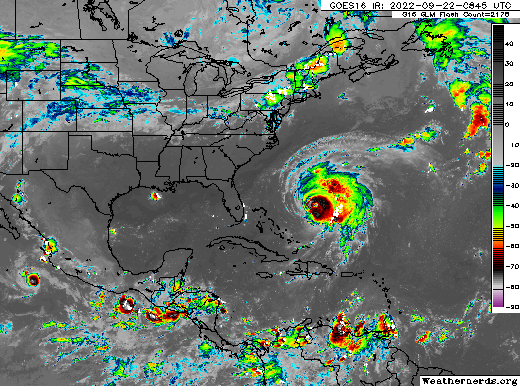
- Hurricane Warnings Issued for Bermuda: Fiona will pass just to the west of Bermuda as a category-4 hurricane tonight. While the strongest winds are forecast to stay offshore, hurricane warnings have been issued for the island as gusts exceeding the category-1 threshold of 74 mph are likely. Rainfall of 2-4" and significant wave action and storm surge on the south and west facing shorelines of Bermuda are anticipated.
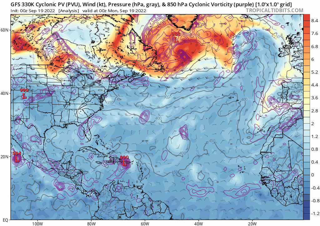
- A Historic Event Unfolding for Atlantic Canada: Simply put, Fiona looks to be one of the strongest transitioning hurricane events to ever impact Atlantic Canada. The forecast reasoning is unchanged and is provided in yesterday's update. Conditions will deteriorate Friday with landfall Saturday morning in eastern Nova Scotia. Sustained winds of category-2 (96-110 mph) and potentially gusts to category-3 strength are anticipated, also accompanied by record storm surge heights for parts of the Atlantic coast of eastern Nova Scotia, the Gulf of St. Lawrence and western Newfoundland. As Fiona completes the weekend transition to a mid-latitude cyclone, the forward speed will significantly slow down. Thereafter, widespread 3-6 inch rainfall totals with isolated areas in excess of 10 inches are likely. A number of real-time resources to monitor conditions across Atlantic Canada are provided below.
- Post Fiona, Attention Turns to the Caribbean: A tropical disturbance currently called '98L' will traverse the Caribbean Sea over the weekend into early next week, likely gaining tropical storm and potentially hurricane status in the northwest Caribbean by Monday/Tuesday. Thereafter, multiple scenarios are possible, ranging from a track over the Yucatan Peninsula, the potential to emerge into the central/eastern Gulf of Mexico, or a turn over Cuba and potentially longer term implications for Florida. We discuss the forecast in more detail below, and what Guy Carpenter meteorologists will be watching to bolster confidence in the potential for longer term impacts.
What is Driving the Historic Fiona Event for Atlantic Canada?
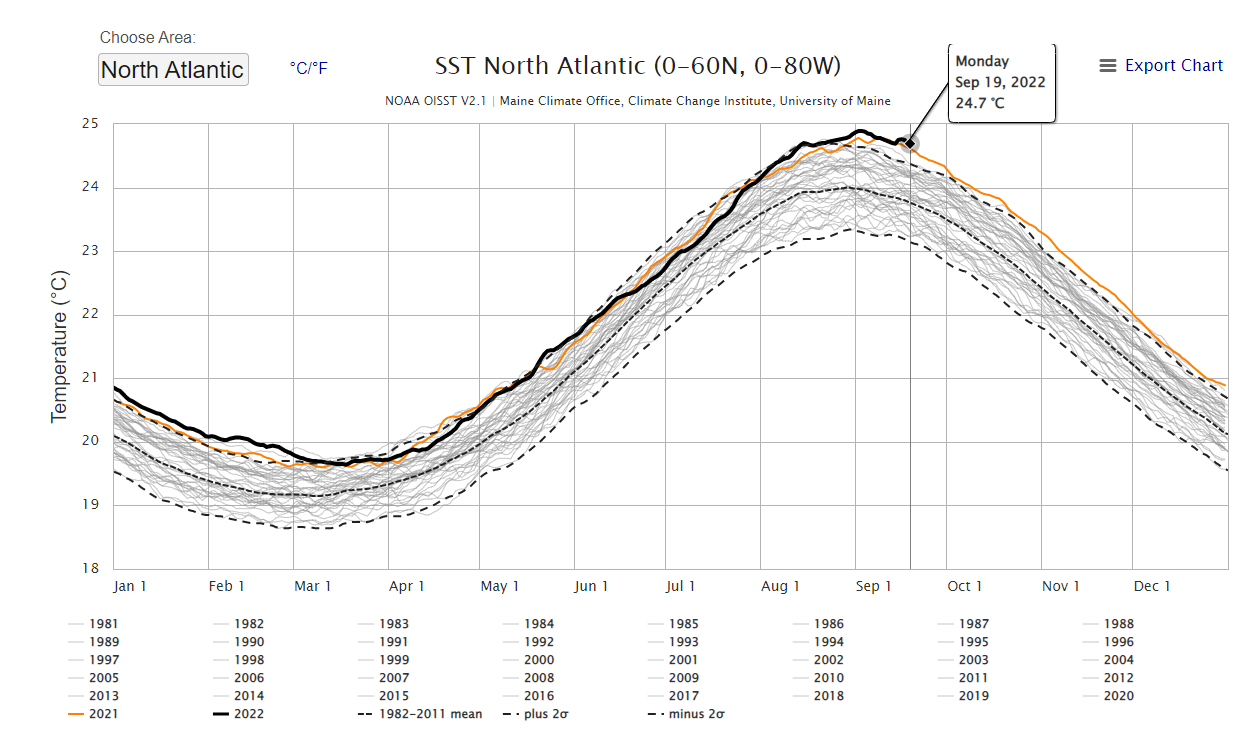
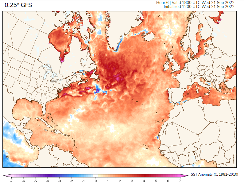
- Record warm north Atlantic sea surface temperatures: The seasonal cycle of sea surface temperatures peak in late August and early September. Over the last 30 days, sea surface temperatures averaged across the northern Atlantic have hit the highest levels on record, as anomalies of up to 10 degrees F warmer than average exist south of Nova Scotia and Newfoundland.
- Merger with the jet stream to invoke a strong transition to a mid-latitude storm system: The most damaging Northeast US and Canada hurricanes on record involve a setup whereby the energy driving intense hurricanes (warm ocean temperatures) shifts to energy driven by the mid-latitude jet steam. A deep trough of low pressure west of Fiona is setting the stage for a textbook example of this transition, accelerating Fiona to the north while the storm maintains tropical characteristics simultaneously connecting to the jet stream.
The Caribbean Disturbance - What to Watch for Longer Term Implications
- Short term disorganization: The tropical wave of note is unusually far south, currently located to the west of Trinidad and Tobago and just north of the Venezuelan coastline. It will likely be several days until the disturbance gains latitude in the central Caribbean and taps into adequately deep and warm sea surface temperatures to achieve some organization.
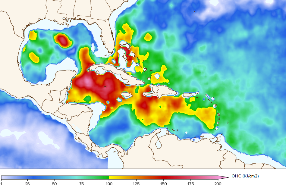
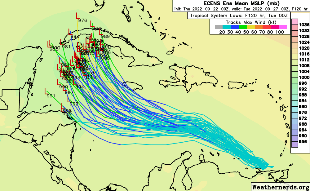
- Sunday/Monday intensification: Assuming the wave does traverse the Caribbean as described above, most models see the potential for a strong tropical storm or hurricane in the northwestern Caribbean by the beginning of next week. In part, this is due to projected tracks over the highest heat content in the entire Atlantic basin. As seen in the range of tracks below, the amount of northward movement will determine whether focus turns to implications for Honduras/Nicaragua on the south/west side of outcomes, Jamaica and the Cayman Islands on the north/east side of scenarios, or a track towards western Cuba and the Yucatan.
- Uncertain long range outcomes beyond seven days: At this long lead time, the range of outcomes is incredibly broad and depends on what has already been discussed. There will likely be weather model guidance that portrays a range of scenarios from significant impacts to the US coastline to innocuous outcomes over the next several days. For the time being, GC meteorologists will be examining model trends to garner details on whether or not this system could become a significant risk to US interests beyond seven days. With the elevated ocean heat content in the central/eastern Gulf of Mexico, tracks over this region would be of most concern from the potential for intensification, as well as notable longer term US impacts.
Additional links of interest:
Fiona Satellite Imagery from CIRA Colorado State
Canada Hurricane Center
U.S. National Hurricane Center
Bermuda Weather Service
PEI Storm Surge Warning System
PEI Weather Conditions
Nova Scotia Emergency Management Operations
Canada Tidal Gauge Network
The next update on Fiona and the Caribbean disturbance will be Friday, September 23, 2022.