Header

Live Event: Nicole Forms East of the Bahamas, Potential to Reach Hurricane Strength before Florida Landfall on Thursday

Hero image

Key Headlines

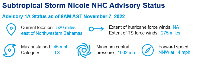
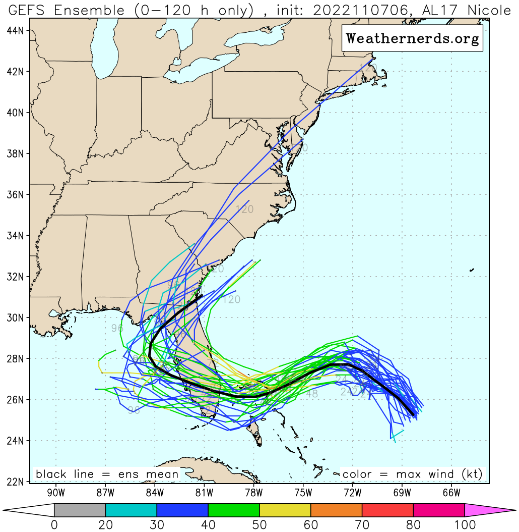
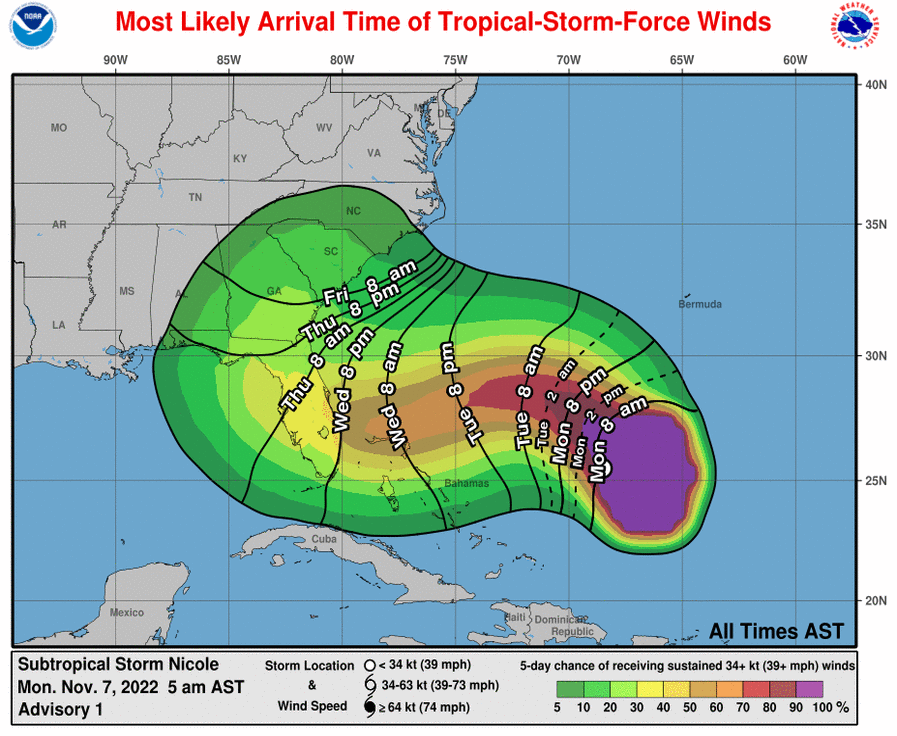
  • Late Season Landfall Likely: Consolidating from a broad area of low pressure, Nicole is expected to strengthen into a strong tropical storm by Wednesday while traversing the northern Bahamas, thereafter crossing the Florida peninsula on Thursday. Tropical Storm watches are issued for the Bahamas, with additional watches for Florida likely later today. By next weekend, Nicole will turn to the northeast and rapidly accelerate in forward speed along the East Coast of the United States.
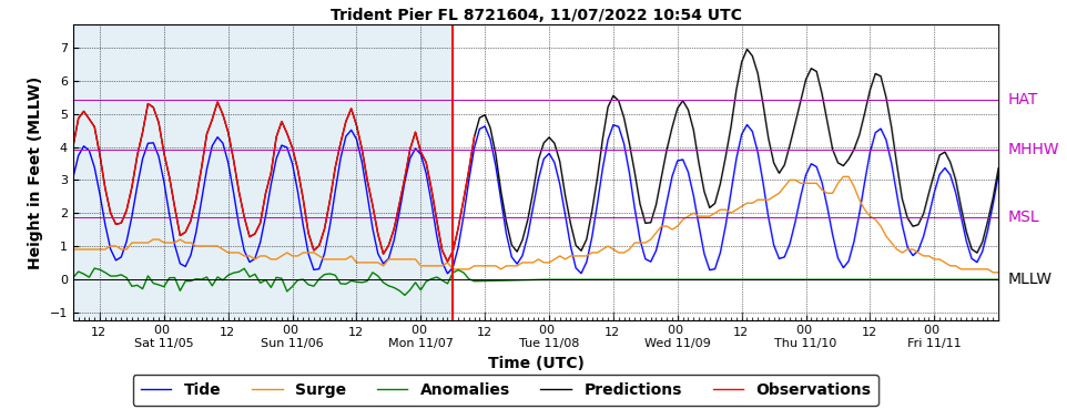
  • Large Circulation Center Means Broad Regional Impacts: As a hybrid tropical/mid-latitude system, tropical storm force winds currently extend 275 miles from the center and are expected to grow to 400 miles before impacting the Bahamas and Florida. As a result, the duration of the event will be lengthy and noteworthy, more so than the severity of conditions. Peak gusts nearing hurricane strength, rainfall of 3 to 8 inches and storm surge of 2 to 4 feet are possible.
  • Landfall Intensity: Ocean temperatures between Nicole and the Bahamas/Florida are running several degrees above average.  The majority of weather models project Nicole attaining a peak intensity of a strong tropical storm. However, intensification to a hurricane is possible given the atmospheric and oceanic conditions. It is unlikely that a peak intensity would exceed Category 1 strength.
Five day model track forecasts for Nicole. Given the hybrid nature of the storm and associated broad wind swath, the exact track is less important than other events. Impacts will be seen hundreds of miles away from the center of circulation.  Source: Weathernerds.
Five day model track forecasts for Nicole. Given the hybrid nature of the storm and associated broad wind swath, the exact track is less important than other events. Impacts will be seen hundreds of miles away from the center of circulation. Source: Weathernerds.
Most likely arrival time of tropical storm force winds (contoured) and probability of sustained tropical storm force winds (shaded).  Source: NHC.
Most likely arrival time of tropical storm force winds (contoured) and probability of sustained tropical storm force winds (shaded). Source: NHC.
High tides along the southeastern US coast are running six to nine inches above average due to the full moon on Tuesday, November 8. Nicole will elevate sea levels further through Thursday resulting in multiple high tides above average, causing significant beach erosion in addition to storm surge of two to four feet above mean high tide.   Source: NHC.
High tides along the southeastern US coast are running six to nine inches above average due to the full moon on Tuesday, November 8. Nicole will elevate sea levels further through Thursday resulting in multiple high tides above average, causing significant beach erosion in addition to storm surge of two to four feet above mean high tide. Source: NHC.
The seven day rainfall forecast highlights the longer term track of Nicole, which may briefly emerge into the Gulf of Mexico before making a turn to the northeast and accelerating in forward speed along the East Coast of the United States next weekend. Isolated totals in excess of 5" are possible across portions of the Florida peninsula. Source: NOAA / WPC.
Footer