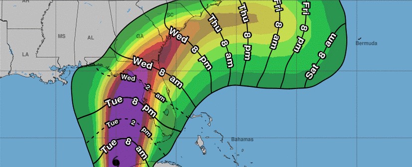

Key Headlines
- Hurricane Idalia is expected by the National Hurricane Center (NHC) to experience a period of rapid intensification as it moves through the eastern Gulf of Mexico today.
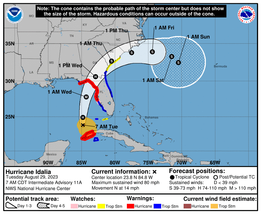
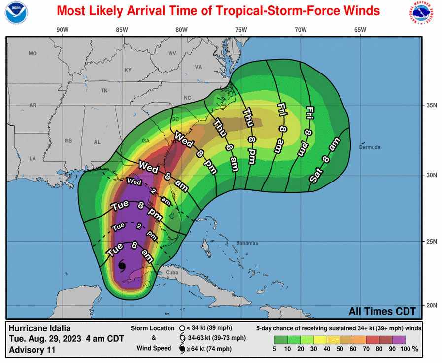
- The storm should accelerate to the north and then north-northeast prior to landfall on the Florida Big Bend region on Wednesday, with onset of conditions late Tuesday. The storm should then move through Georgia and the Carolinas through Thursday.
- Destructive winds and storm surge together with excessive rainfall are expected.
- While some refinements and new developments have emerged in the last 24 hours, the general forecast reasoning and expected impacts are largely unchanged from yesterday – specifics follow below.
NHC Best Forecast
- Track: Idalia was upgraded to hurricane status at 5AM EDT this morning by the NHC after moving into the eastern Gulf of Mexico. Idalia should begin a steady motion to the north and north-northeast between a mid-level ridge to the east and a mid-level disturbance to the west. A passing weather system over the continent will accelerate this motion on Wednesday. Model guidance is in general agreement on this scenario, and accounting for these factors the NHC best forecast is for landfall somewhere on the Florida Big Bend Region on Wednesday, with onset of conditions later today.
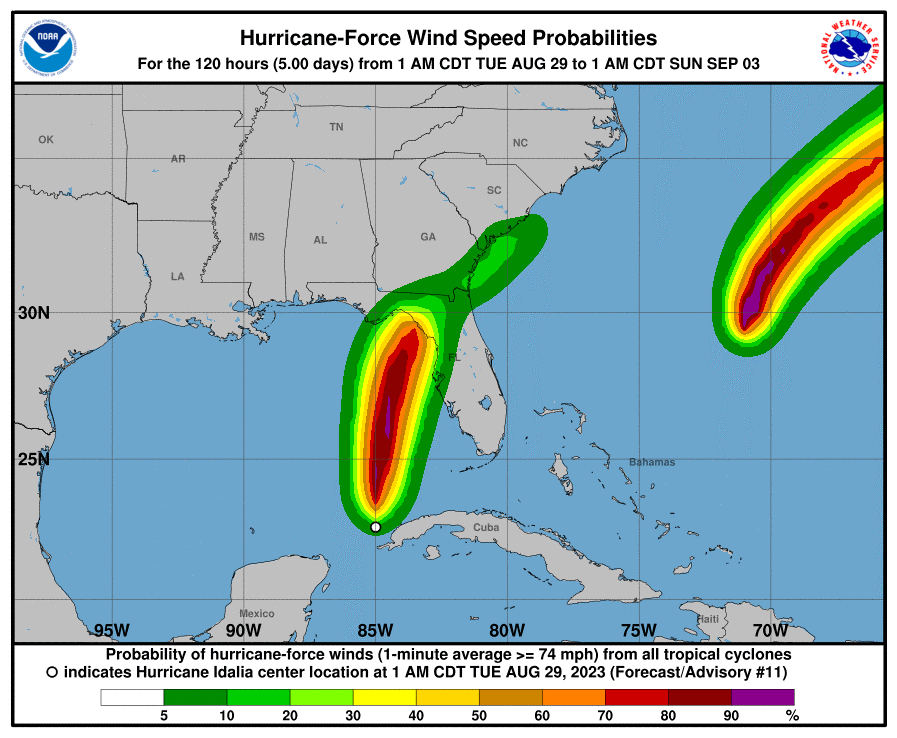
- Intensity: Concerning intensity, Idalia is now a category-1 hurricane with a clearly defined and organizing circulation, within an area of extensive deep cloud cover (known as a central dense overcast). As Idalia continues moving across the eastern Gulf of Mexico, it will encounter very warm waters associated with the loop current, in a moist environment, with relaxing wind shear. The passing weather system over the continent will also act to ventilate and intensify the storm. Considering these factors, a period of rapid intensification appears inevitable and the NHC is expecting Idalia to strengthen into a major category-3 hurricane prior to landfall.
- Post Landfall: Following landfall, Idalia should weaken to tropical storm status while crossing Georgia and into the Carolinas. Idalia should move offshore into the Atlantic on Thursday.
Historical Context
- Only four other storms in recorded history since 1851 have affected an area within 100 miles of Cedar Key, Florida in the Florida Big Bend Region.
- These include the Labor Day 1935 Hurricane which rendered historic impacts to the Florida Keys and Florida Gulf Coast region, as well as hurricanes from 1896, and 1921.
- Hurricanes in this region typically move along a track to the north to northwest, leaving the northeast corner of the Florida Gulf Coast (known as the Big Bend Region) with fewer hurricane landfalls as compared to areas further west along the Northern Gulf Coast.
Storm Surge
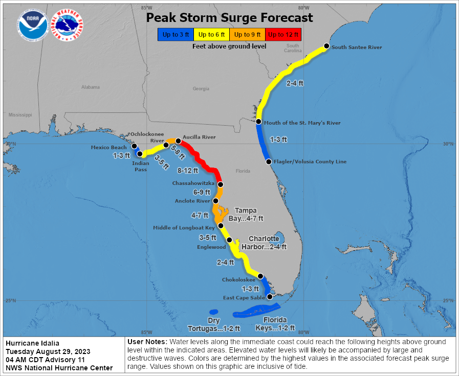
A storm surge warning is in effect along portions of Florida’s Gulf Coast including Tampa Bay and the Big Bend Region. An inundation of 8 to 12 feet is possible along and to the right of landfall, which has the potential to severely impact structures and infrastructure, including rendering roadways impassable and destroying bridges. Based on the current NHC forecast, the largest storm surge is expected between Chassahowitzka and the Aucilla River. This includes the communities of Crystal River, Cedar Key and Steinhatchee.
The Big Bend Region of the Florida Gulf Coast is particularly prone to large storm surges due to the depth and shape of the underwater terrain (bathymetry). The West Florida Shelf is a wide and very shallow ledge that extends nearly 200 miles off the Gulf Coast, which allows water to effectively pile up as hurricane winds drag water toward the shore. The geometry of the Big Bend coastline also allows water to funnel into the region from both the north and south.
Expected Impacts
Hurricane, Tropical Storm and Storm Surge watches and warnings are active for areas under threat - specifics can be found at www.nhc.noaa.gov.
- Storm Surge: As noted above, a significant storm surge is expected. Seawater inundation as high as 8-12 feet above ground is forecast for portions of the Florida Big Bend region, with impactful levels of 4-7 feet for Tampa Bay. The surge envelope is expected to extend from near Mexico Beach to the Florida Keys, and then on the Atlantic Coast from near the Flagler/Volusia Line to the South Santee River in South Carolina. These estimates will change as the situation evolves. The storm surge will bring damage to structures along the coast and connected waterways due to inundation and water velocity, with more severe impacts along the immediate coast due to wave battering.
- Wind: Idalia should bring major hurricane wind conditions to the Florida Big Bend Region and adjacent inland areas. Modest wind damage can be expected for affected structures meeting more recent building codes, with more substantial damage for older or less-resilient structures. Impacts will extend well away from the center of circulation to affect much of the Florida Peninsula, with the most severe effects along and to the right of the track. Tropical storm wind impacts will likely affect portions of Georgia and the Carolinas. Downed trees and powerlines can be expected over a widespread area.
- Inland Flooding: Heavy rainfall amounts of 4-8 inches, with higher amounts to 12 inches are possible for portions of Florida, Georgia and the Carolinas through Thursday. This will bring the threat of inland flooding for affected areas.

Additional links of interest:
U.S. National Hurricane Center
U.S. National Weather Service
NWS Tampa
Statements from official forecast and emergency management agencies supersede this update, and should be closely followed concerning matters of personal safety.