
Key Headlines
- Wildfire History in Hawaii: Wildfires are common historically in Hawaii. A warming and drying climate, coupled with a land use conversion to non-native grass species, have increased the risk from wildfires in the past century.
- Meteorological Perfect Storm: A moderate to severe drought over Hawaii, coupled with strong winds and dry air associated with the passage of Hurricane Dora to the south created a meteorological landscape that was conducive to fire ignition and rapid fire spread.
- Potential Impacts: Early estimates from satellite hot spot detections indicate that several hundreds to even thousands of structures in Lahaina may have been impacted by fire and smoke. Infrastructure, including communications, have been heavily impacted resulting in a lack of information about fire containment and forecast.
History of Wildfire in Hawaii
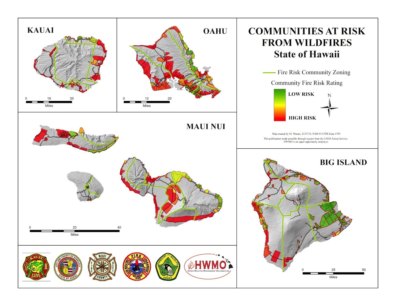
- Wildfires are Common in Hawaii: Historically, the percent of acreage burned to total land acreage across Hawaii is comparable to or even exceeds that of the fire-prone western US. Wildfires were once limited to volcanic eruptions and the occasional lightning strike, however in modern times humans cause nearly all of the wildifre ignitions in Hawaii. The map below highlights the Communities at Risk from Wildfires in the State of Hawaii, showing high risk areas in red. All of the areas where fire is currently burning on Maui are in areas designated as "High Risk", including Lahaina.
- Wildfire Threat is Growing: Average burned area has increased by over 400% in Hawaii over the past century, mainly due to humans introducing non-native species of fire prone grasses to the landscape. Furthermore, a warming and drying of the climate has created a landscape that is more conducive to burning, coupled with a greater percentage of land area converted to non-native grasses. Traditionally dry areas in the lee of the mountains are now even drier, including the region of Maui where Lahaina is located.
Meteorological Perfect Storm
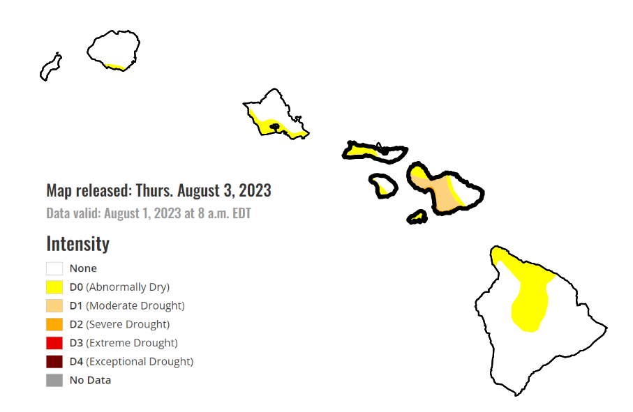
- Moderate to Severe Drought in Maui: After above average rainfall in the winter months of December 2022 and January 2023, rainfall has since been below average across Maui. As a result, moderate drought conditions have developed over the last six months. The western side of Maui where Lahaina is located is traditionally the drier side of the island due to east-to-west trade winds. Hence, drier than average conditions for much of 2023 resulted in a lack of meaningful precipitation events and prime conditions for grass vegetation to ignite
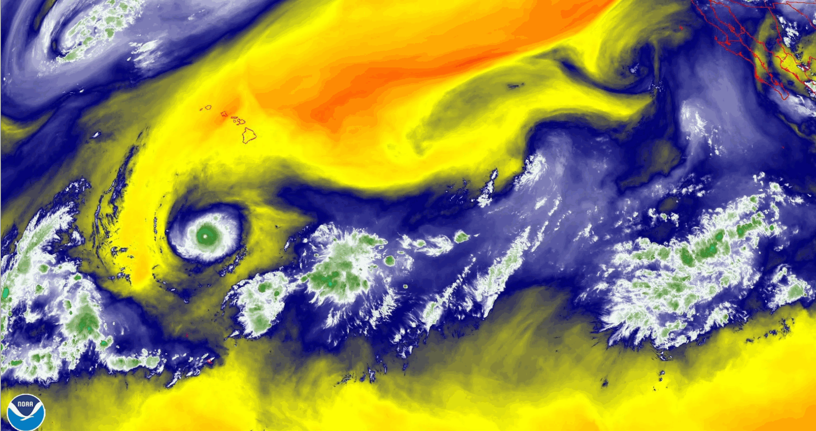
- Excessive Winds and Abnormally Dry Air Mass: Stronger than average high pressure to the north of Hawaii, along with category-4 Hurricane Dora passing well to the south of the Hawaii island chain resulted in ideal conditions to enhance the traditional trade winds. As seen in the water vapor image below, abnormally dry air (orange/red shades) moved over Hawaii as Dora passed to the south. This resulted in a combination of very dry air coincident with wind gusts in excess of 50 mph across each island of the state.

Developing Impacts
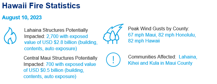
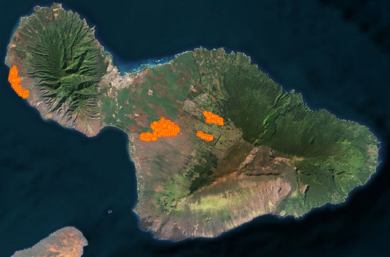
- Structures Impacted in Lahaina: Guy Carpenter developed an estimate of the wildfire boundary by utilizing the NASA VIIRS 375 m Active Fire Product and placing a 500 m buffer around hot spot detection points. This estimated perimeter is pictured below. For the event in Lahaina (the westernmost perimeter in the image) it is estimated that ~2,700 structures totaling $2.8B USD in exposure were in the area of active fire. This estimate accounts for building, contents, and automobile exposure based on U.S. Army National Structure Inventory data. Three additional fires are also affecting central Maui that collectively are impacting an estimated 700 structures, with an exposure value of approximately $500 million USD based on U.S. Army National Structure Invenstory data. Structure affected estimates are likely overly conservative given the 500 m buffer around hot spots. Furthermore, while structures may have been inside the perimeter, not all structures will have burned.
- Limited Information on Containment: The fire has affected communications on the island, resulting in a lack of information on containment. As of 4:30 am on Thursday, the Maui Fire Department stated the fire was still active, with no information available on containment. The forecast is for clear skies with winds abating, and all red flag warnings have expired. Weakening winds will improve firefighting and containment operations.
Additional links of interest:
Hawaii Wildfire Management Organization
Maui County Fire Updates
National Weather Service Honolulu, HI
Maui Now Local News
Hawaii Emergency Management Agency