
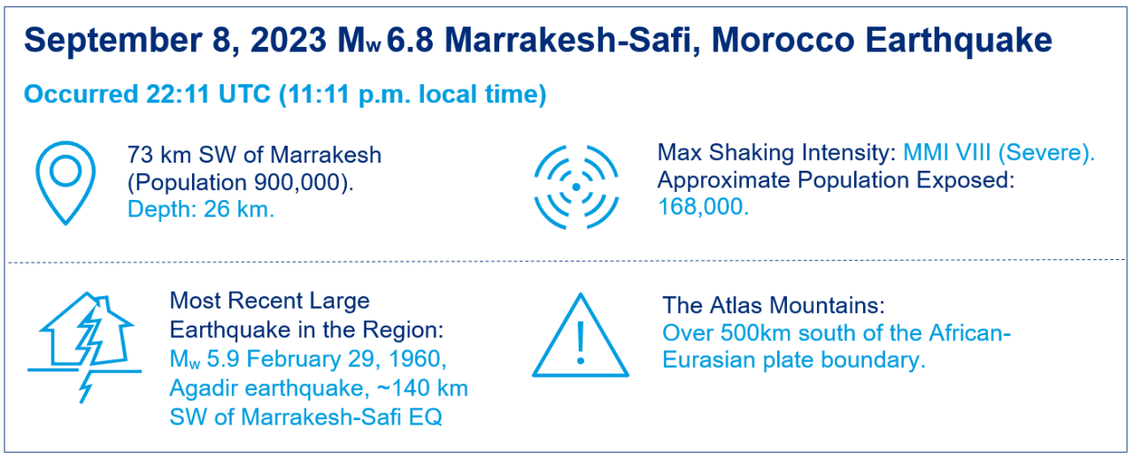
- A strong Mw 6.8 earthquake struck in the Atlas Mountains on the evening of September 8, ~70km SW of Marrakesh.
- This is the largest magnitude earthquake recorded in the Atlas Mountains. The closest notable earthquake was the Mw 5.9 event in Agadir in 1960, ~140km SW of this event. There have been 9 Mw 5.0 and larger earthquakes within 500km of the September 8 event since 1900, but none over Mw 6.0.
- There have been 2 small aftershocks (Mw 4.9 and 4.2) in the 3 days following the Mw 6.8 earthquake.
- At the time of writing, more than 2,400 fatalities and 2,400 injuries have been reported by Morocco’s Interior Ministry.
Physical Discussion of the Earthquakes
The Mw 6.8 Marrakesh-Safi earthquake struck at 11:11 p.m. local time (22:11 UTC) on September 8, 2023, at a shallow depth of 26 km. The epicenter was located in the Atlas Mountains, near the town of Ighil and approximately 73 km southwest of Marrakesh, the fourth-largest city in Morocco with a population of more than 900,000. The initial estimate by the US Geological Survey (USGS) indicates that the rupture was approximately 30 km in length and 20 km in width, occurred on a fault dipping at approximately 69°, and maximum slip may have exceeded 1.5 meters. Severe shaking (VIII) was reported on the Modified Mercalli Intensity (MMI) scale in regions surrounding the epicenter, with the US Geological Survey (USGS) PAGER system estimating that approximately 168,000 people were exposed to this intensity. More than 3 million people, including 839,000 in Marrakesh, were exposed to strong shaking (MMI VI), which is the level at which structural damage begins to be observed for non-engineered structures. The earthquake also reportedly was felt in parts of Mauritania, Algeria, Gibraltar, Spain and Portugal.
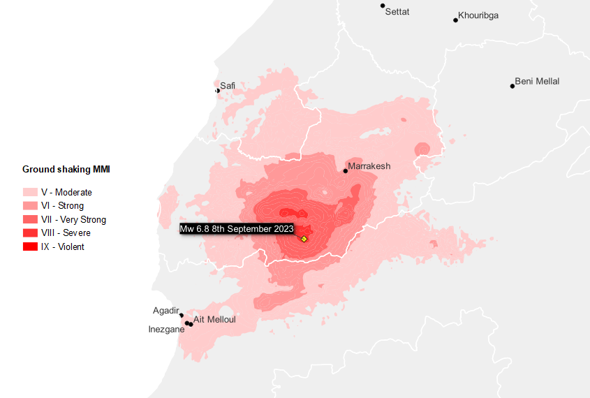
The USGS ground-shaking footprint for this earthquake is shown in Figure 1. It should be noted that USGS footprints are simulated based on observations from seismic recording stations and damage reports, so some uncertainty remains and updates do occur in the days or weeks following a major event. The Marrakesh-Safi earthquake was not preceded by any significant precursory seismicity and, at the time of this writing, has been followed by 2 notable aftershocks: a Mw 4.9 earthquake occurred within 20 minutes of the Marrakesh-Safi earthquake, and a Mw 4.2 earthquake occurred on September 10. Some studies suggest that the stress released by the Marrakesh-Safi earthquake may have been transferred onto neighboring faults, increasing their potential for rupture. Given that the Marrakesh-Safi earthquake had a magnitude of Mw 6.8, there is a possibility that aftershocks greater than Mw 5.0 may occur. However, the low initial aftershock rate and general seismic inactivity in the area may indicate a reduced likelihood of this.
Figure 1: USGS simulated ground shaking intensity of the Mw 6.8 Marrakesh-Safi earthquake (11:11 p.m. local time).
Seismotectonic Context
The Mw 6.8 Marrakesh-Safi earthquake occurred in the Atlas Mountains within the African tectonic plate, more than 500 km south of the plate boundary between the African Plate and the Eurasian Plate. Most of Morocco’s damaging earthquakes occur in the north of the country and are associated with the African-Eurasian plate boundary. Seismicity does occur in the Atlas Ranges, but tends to be more sparsely distributed, as the major mountain-building phase of the Atlas Mountains’ evolution occurred more than 20 million years ago. The fault hosting the Mw 6.8 Marrakesh-Safi earthquake (possibly the North Atlas Fault, as indicated by the USGS) has an estimated strike of 255°, similar to the ENE-WSW strike of most major faults in the Atlas Mountains. The major faults (mapped by the Global Earthquake Model) and plate boundaries around Morocco are shown in Figure 2.
Figure 2: Movement of plate boundaries and location of mapped faults around Morocco.
![Source: Global Earthquake Model, Peter Bird, [1] Graphics: Guy Carpenter](/insights/2023/09/post-event-morocco-earthquake/_jcr_content/root/container/container/image_399691646.coreimg.png/1694601307698/morocco-2.png)
The historical catalog shows that there have been 9 earthquakes of Mw 5.0 or greater since 1900 within 500 km of the Marrakesh-Safi earthquake epicenter, but none greater than Mw 6.0. The largest recorded event in this region was the 1960 Mw 5.9 Agadir earthquake. While events with larger magnitudes are not unprecedented across Morocco, these have tended to occur off the north coast, such as the sequence of events around Al Hoceima in 1994 (Mw 6.0), 2004 (Mw 6.4) and 2016 (Mw 6.3). However, the Global Earthquake Model estimates that an event of Mw 6.8 or greater could occur in the Marrakesh-Safi region approximately every 3,500 years.
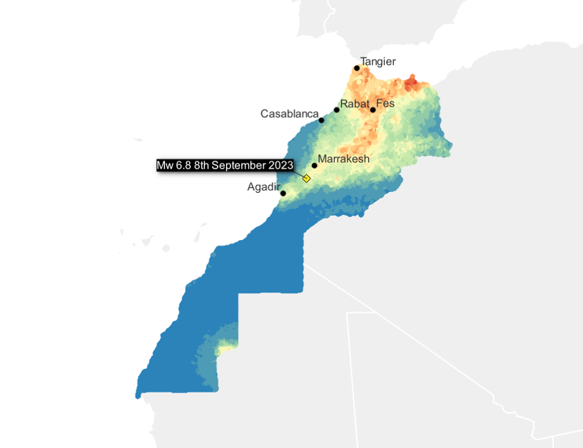
The Global Earthquake Model (GEM) North African (NAF) hazard map is displayed in Figure 3. This shows estimates for the 475-year return period peak ground acceleration (PGA), including soil amplification. In the historic center of Marrakesh, GEM estimate the 475-year hazard to be 0.21g. In the same location, the USGS estimate that the PGA of the Marrakech-Safi earthquake reached 0.18g. Closer to the epicenter, the PGA of the Marrakesh-Safi event will have exceeded the 475-year hazard.
Figure 3: Global Earthquake Model 475-year return period peak ground acceleration (PGA), including soil amplification.
Damage Impacts
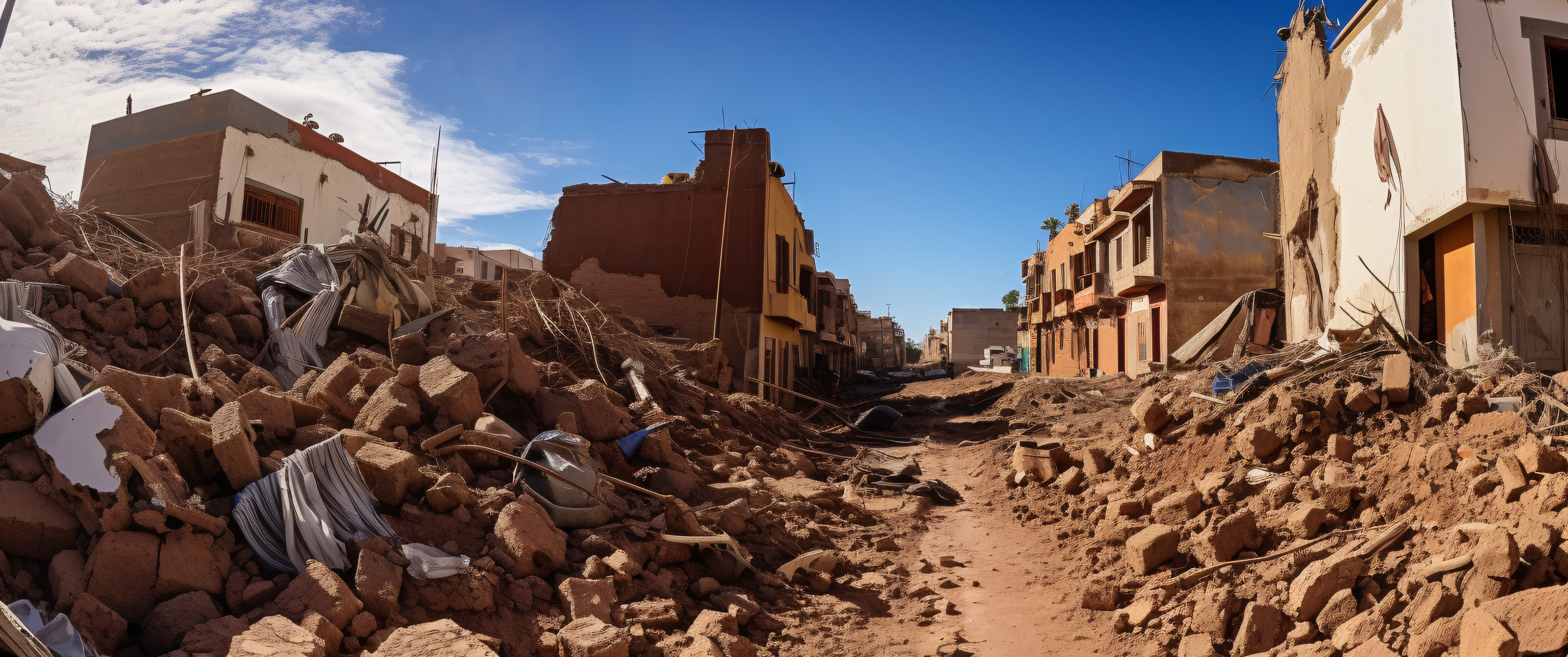
As the death toll from the earthquake surpasses 2,400 and while more than 1,400 are said to be in a critical state, news reports indicate that there has been extensive damage to buildings and infrastructure across the region. The World Health Organization has reported more than 300,000 people have been affected by the disaster, and government officials in Morocco have reported damages in the cities of Marrakesh, Casablanca, Rabat and Fes. Media reports indicate building collapses in the medina area of Marrakesh, a UNESCO world heritage site, as well as significant damage to the city walls and to the historically important 12th century Koutoubia mosque. Further severe damage is expected in remote mountain villages, many of which are currently inaccessible due to earthquake-induced landslides.
Morocco has had a seismic building code since 2004. This has included provisions for earthen construction, which tends to perform poorly in earthquakes, since 2014. It is unlikely that the building codes will have been applied retrospectively. Currently, there is no clear picture on how well the building code has been enforced for newer buildings, particularly in rural areas. Given the prevalence of historical buildings in Marrakesh and earthen construction in rural areas close to the epicenter, significant building damage is therefore to be expected.
Guy Carpenter scientists and engineers will review reported damage in order to explain the scale of the destruction that has been observed. This will also consider a survey of the building codes and their efficacy in the region, including the quality of regulation and enforcement.
Loss Estimation
Morocco has a private insurance scheme covering close to 9 million people and has established a public solidarity fund (FSEC), separate from the Fight Against the Effects of Natural Disasters fund (FLCN), targeted at the poorest and most vulnerable households (an estimated 6 million people). The combined private and public schemes can provide about USD 100 million (approximately MAD 1 billion) in compensations every year.
Guy Carpenter is working with clients to provide early loss estimates for their portfolios. We are using scenario events taken from the stochastic catalog of our proprietary GCAT model that are similar to the Marrakesh-Safi earthquake, both in terms of magnitude and location. We are also working on developing a custom event footprint for the earthquake, which we will use to produce loss estimates based on the GCAT vulnerability model. Please reach out to your account executive or catastrophe analysts if you require further assistance.
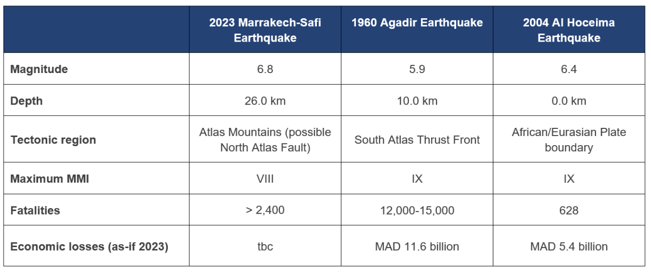
Comparison with Historical Events
The 2 most significant events in Morocco in recent history are the 1960 Mw 5.9 Agadir earthquake and the 2004 Mw 6.4 Al Hoceima earthquake. Table 1 compares the characteristics of these events.
Table 1: Comparison of the Marrakesh-Safi earthquake with recent significant events in Morocco.
Download the Post Event report
Sources: [1] Bird, P. (2003). An updated digital model of plate boundaries. Geochemistry, Geophysics, Geosystems, 4(3), 1027. https://github.com/fraxen/tectonicplates
United States Geological Survey (USGS), Global Earthquake Model, Temblor, Inc., AXCO, BBC, Reuters, GFZ Potsdam