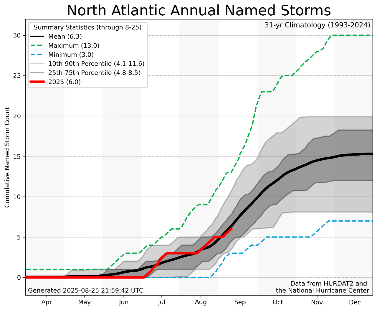
- The 2025 Atlantic Hurricane season has been defined by generally average activity as of late August 2025. 6 named storms have formed to date, a pace that is slightly below the 1993-2024 climatological mean.
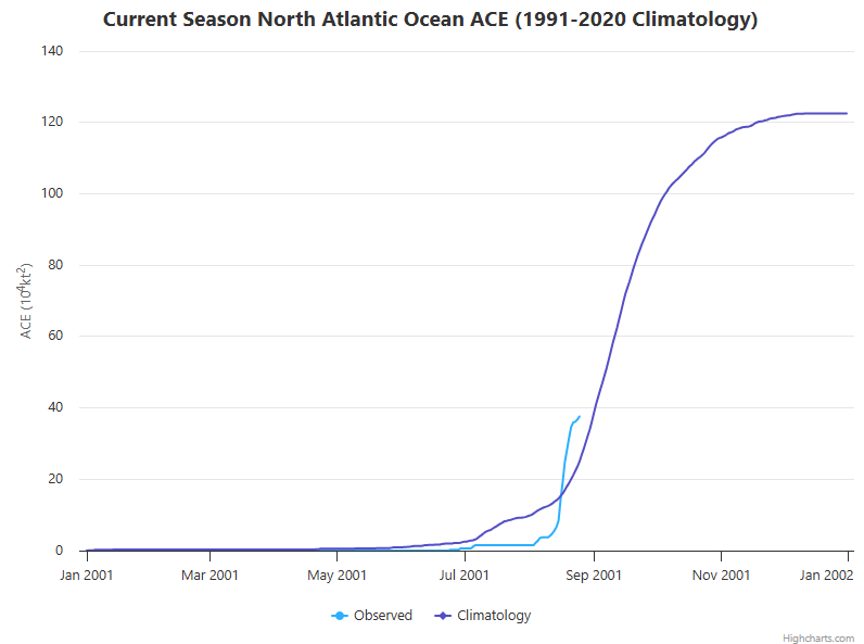
- Accumulated Cyclone Energy, a metric which analyzes both the intensity and duration of tropical cyclones, is slightly above normal year-to-date compared to climatology due to the strength and duration of Hurricane Erin. Otherwise, most Atlantic tropical cyclones in 2025 have been weak and short-lived tropical storms.
- Two main variables have prohibited an active start to the season: plentiful dry Saharan air and wind shear have acted to limit the intensification of systems.
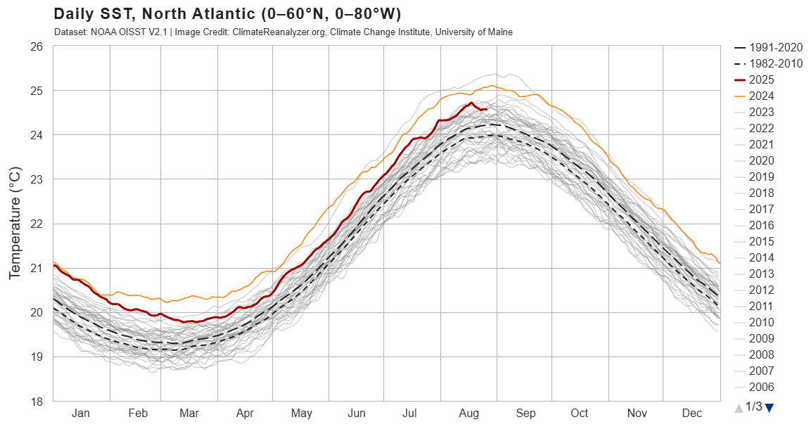
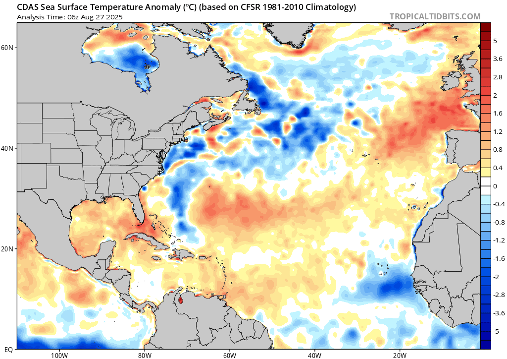
- Despite the adverse atmospheric conditions, above average sea surface temperatures (SSTs) have been in place across the Southwestern Atlantic, and the Gulf of Mexico/America. This sea surface temperature configuration would favor storms to develop and/or intensify closer to land.
Today’s seasonal update provides a review of Hurricane Erin, a discussion of September storm formation potential and an update on ENSO.
2025 ATLANTIC HURRICANE Season Update
Huricane Erin - A Fortunate Fish Storm
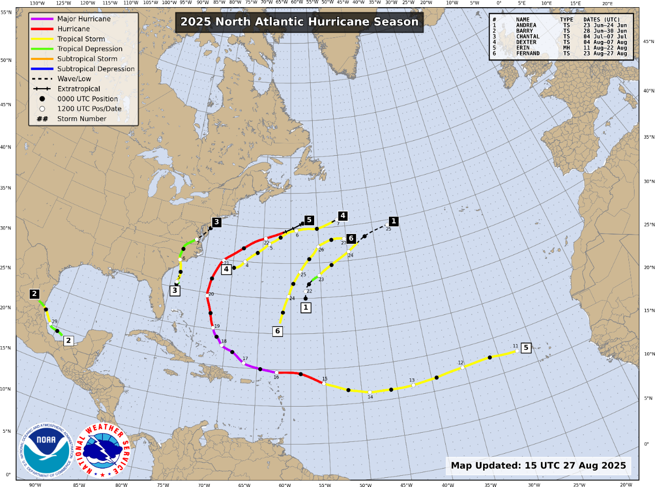
Hurricane Erin was a large and intense hurricane that tracked from the Cape Verde Islands to just south of Atlantic Canada from August 11th to 22nd.
- Formation: After initially struggling with cooler than normal waters and a stable and dry atmosphere in the Tropical Eastern Atlantic, Erin underwent an impressive rapid intensification episode.
- Historic Rapid Intensification: In just 12 hours, Erin increased its windspeed by approximately 65 mph and its central pressure dropped by 55mb, the 3rd largest wind speed increase and 3rd largest pressure drop observed over a 12-hour period since 1980. Erin’s rapid intensification was the most prolific to occur in the Atlantic basin before the month of September. As a result of this historic rapid intensification episode, Erin peaked as a category 5 hurricane with maximum sustained winds of 160mph while tracking just north of the Greater Antilles.
- Impacts from Track Between US and Bermuda: Following its peak intensity, Erin paralleled the East Coast of the United States. While the hurricane’s peak winds diminished as it tracked northward, Erin transformed into an abnormally large storm with its tropical storm force wind field expanding to greater than 500 nautical miles across, a size greater than the 90th percentile of observed storms that have traversed the Southwestern Atlantic. While Erin never made direct landfall, coastal flooding, overwash, and damaging surf were observed along the East Coast of North America from Georgia to Atlantic Canada. Due to Erin’s size, tropical storm force winds were observed on the Outer Banks of North Carolina, despite the eye of the hurricane passing roughly 200 miles east of Cape Hatteras.
September Outlook
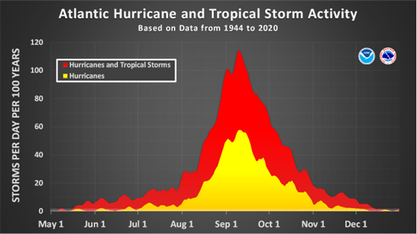
Despite the approaching climatological peak of the Atlantic hurricane season, limited new tropical cyclone activity is expected into the first third September.
- Atmospheric Conditions Not Favorable to Start the Month: Above average wind shear and dry air across the Tropical Atlantic will persist over the next several weeks, atmospheric conditions hostile to tropical cyclone development.
- Expect Uptick Mid to Late September: This pause in activity is likely temporary, as generally above average SSTs across the Atlantic should fuel storm activity once the unfavorable pattern passes. A large region of cool SST anomalies over the Western Atlantic is the result of Erin upwelling cool water to the surface in its wake. Abnormally cool conditions across the American Southeast have contributed to additional cooling of the SSTs in this area, though there should be a gradual warming of Erin’s “cold wake” moving into September.
- Areas of Heightened Concern: The Gulf of Mexico/America contains SSTs well above normal, potentially fueling future tropical cyclone development and intensification close to the Gulf Coast.
ENSO Update
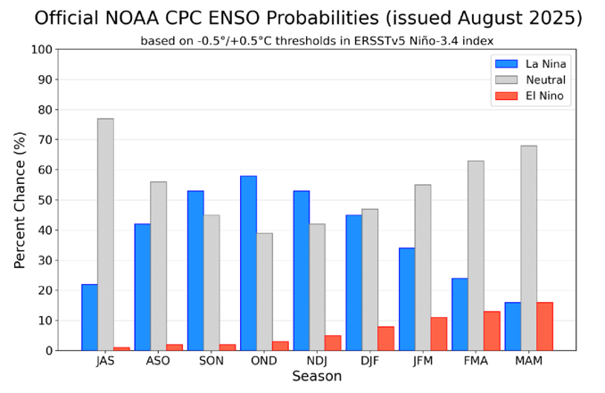
Late Season La Niña Increasingly Possible: Recent El Niño Southern Oscillation (ENSO) forecasts from NOAA indicate that there is an increasing chance of a transition to a weak La Niña in the latter half of the hurricane season. La Niña conditions typically decrease wind shear across the Atlantic basin, enhancing tropical cyclone activity.
Backloaded Season? The combination of warm water and emerging weak La Niña conditions indicate that the height of activity for the 2025 Atlantic Hurricane Season may occur later in the season than the standard mid-September peak, and that opportunities for tropical cyclone development may persist later into the season than normal.
