

October 29, 2025
Key Headlines
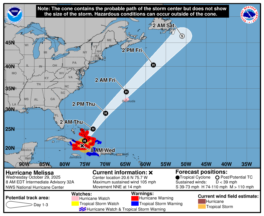
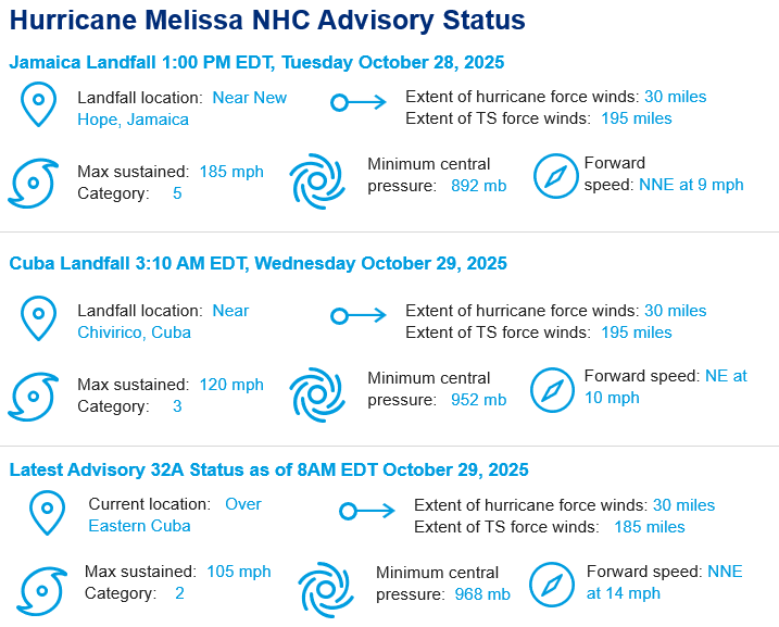
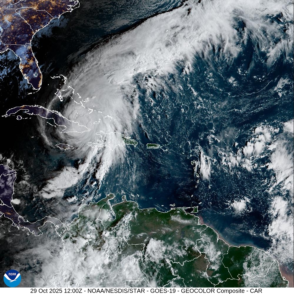
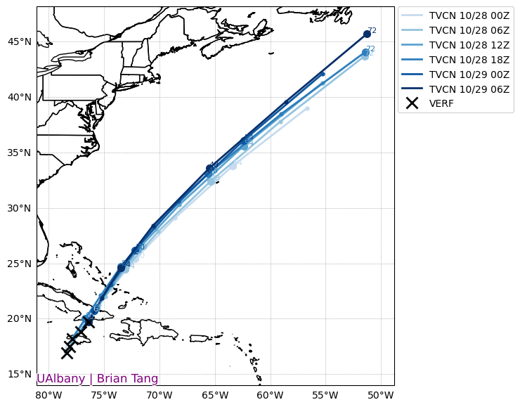
- Current Conditions: At 8 AM EDT, the National Hurricane Center has listed Melissa as a 105-mph category 2 hurricane 205 miles south of the Central Bahamas and 45 miles northwest of Guantanamo Bay, Cuba. Due to land interaction from landfalls in western Jamaica and eastern Cuba, Melissa has dropped in intensity by 70 mph between 8 am EDT yesterday and today. The current estimated motion is north-northeast at 14 mph. Melissa is moving faster this morning and is expected to turn slightly to the northeast as it accelerates towards Bermuda. As of 8 am EDT, the hurricane was centered inland over eastern Cuba, where damaging winds and heavy rainfall continue across the region. Life-threatening storm surge, flash flooding and landslides, and damaging hurricane winds are forecasted for eastern Cuba throughout the morning. Hurricane warnings are in effect for southeastern and central Bahamas, and Cuban provinces of Granma, Santiago de Cuba, Guantanamo, Las Tunas, and Holguin. A hurricane watch is in effect for Bermuda. Tropical Storm warnings are in effect for Haiti, Turks and Caicos Islands, and the Cuban province of Camaguey.
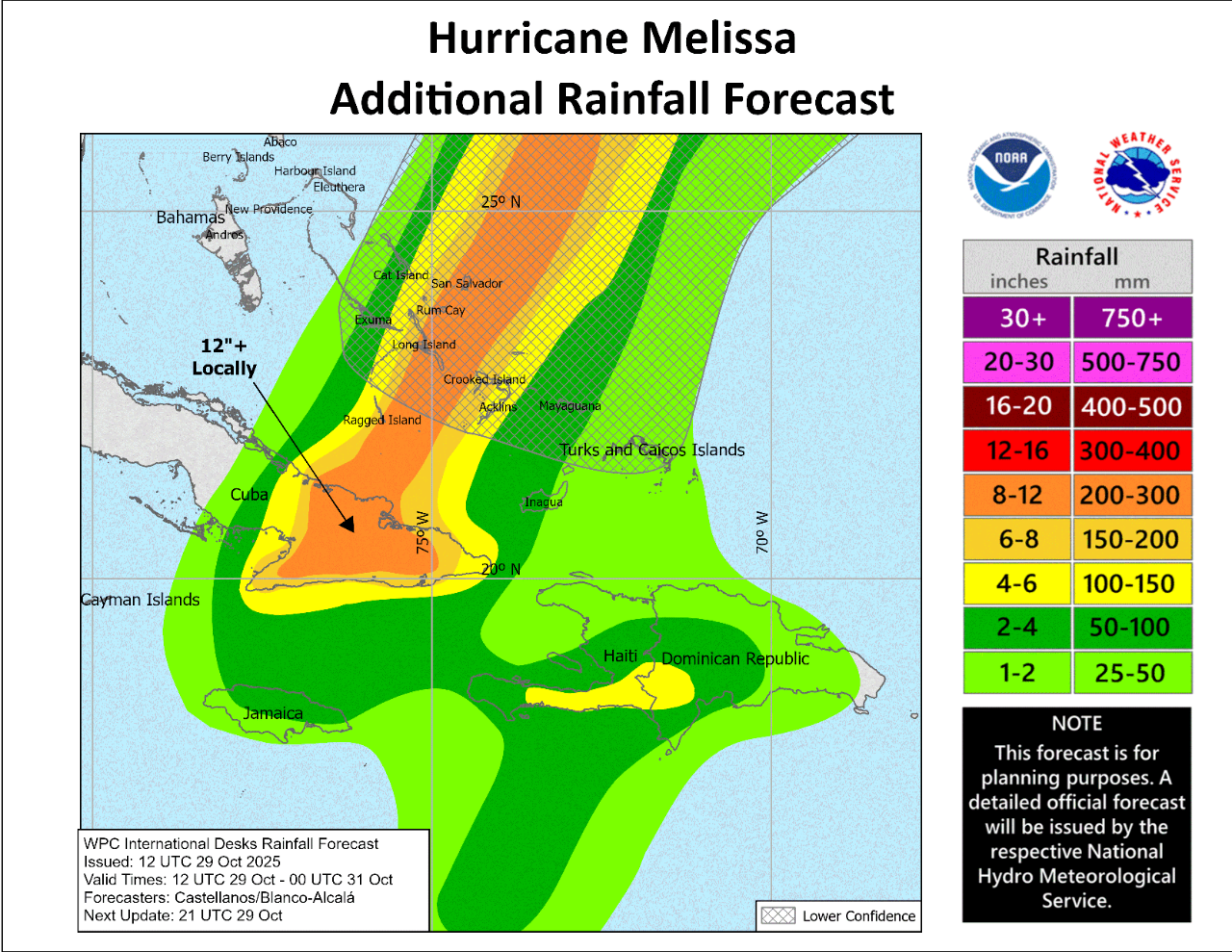
- Bahamas Forecast: The center of Melissa is expected to move offshore of Eastern Cuba this morning and move across the southeastern or central Bahamas later today. The most likely track is between Crooked Island and Long Island in the Bahamas at category 2 strength but a landfall on either island is possible. Regardless of whether Melissa makes landfall, dangerous conditions are expected on these islands with life-threatening surge, rainfall, and wind gusts. Over the Southeastern Bahamas, storm total rainfall of 5 to 10 inches is expected today, which will result in areas of flash flooding. Peak wind gusts are expected to exceed 100 mph. Storm surge heights could reach 5 to 8 feet above ground level, near and to the southeast of where the center of Melissa tracks. Minor coastal flooding and rainfall totals of 1 to 3 inches are expected for Turks and Caicos.
- Bermuda Forecast and Long-Range Outlook: Late Thursday afternoon into Thursday night, there is potential for Melissa to bring hurricane conditions to Bermuda as a strong category 1 or weak category 2 hurricane. Recent forecast consensus has shifted slightly to the northwest over the last 24 hours which reduces the potential for significant impacts in Bermuda. Regardless, Melissa’s tropical storm winds are expected to broaden by Thursday and the southeastern side of the storm is forecasted to be relatively stronger. By Thursday morning, it will be much clearer whether Bermuda should expect tropical storm or hurricane conditions. Notably, the track shift to the northwest has increased the likelihood of tropical or extratropical storm impacts to Newfoundland, Canada. There is still low probability of damaging conditions but additional track shifts to the northwest would change this outlook.
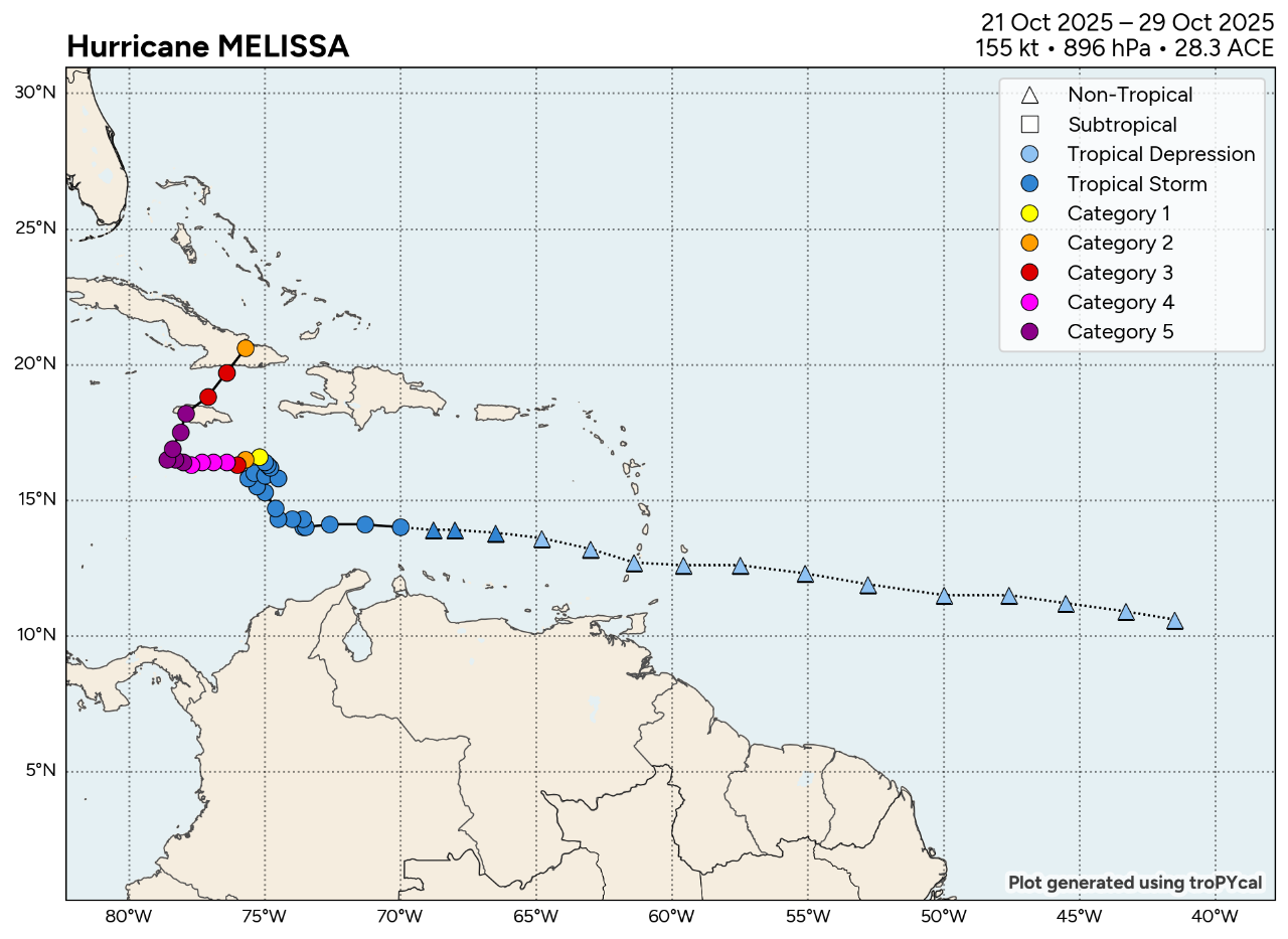
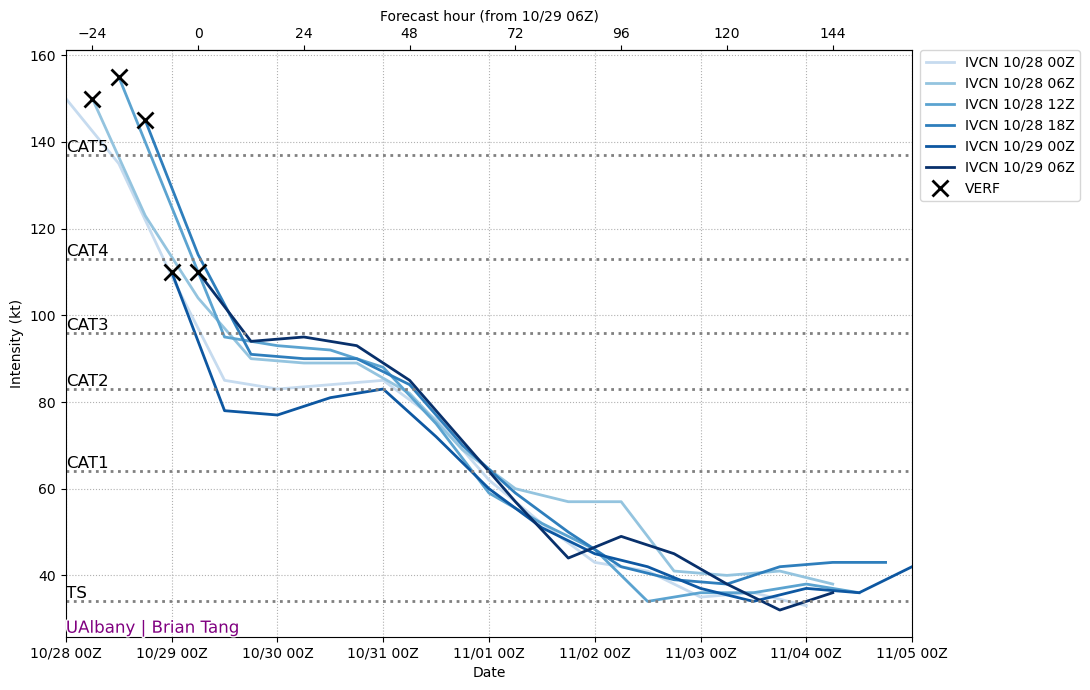
- Historic Landfall in Jamaica: At 1 pm EDT on Tuesday, Melissa made landfall as an 892 mb, category 5 hurricane with 185 mph winds. The extreme intensity of Melissa broke multiple records:
- 892 mb pressure ties 1935 Labor Day Hurricane for most intense
- 185 mph winds tied for strongest landfall in Atlantic Basin
- The latest Atlantic storm on record to record a central pressure below 900 mb (9 days later than Wilma [2005]- the previous record holder)
- Tied for the 3rd most intense hurricane on record (since 1851) in the Atlantic Basin using pressure
- The only Atlantic basin storm on record to make landfall under 900 mb after September 3rd
- A dropsonde released by the NOAA Hurricane Hunters at 9:50 a.m. EDT Tuesday, Oct. 28, in the south-southeastern eyewall of Melissa, recorded a wind gust of 252 mph at an altitude of 657 feet. According to Yale Climate Connections, if validated, this would be a world record for the highest wind gust ever measured by a dropsonde.
Additional links of interest