James Waller, Ph.D, Research Meteorologist
A New York Times article titled "Conditions That Form More Hurricanes Also Protect U.S., Study Finds" (1) notes a hurricane "shield" for the U.S. coast during busy hurricane seasons. The article, based on recent research by James Kossin, (2) provides valuable insight, including some notes of caution from other experts in the field, but the observations should be treated with a moment of pause. Some key points to consider:
- The "hurricane drought" is less remarkable, considering wind uncertainty and the definition of a major hurricane itself,
- Intensity forecasting is a challenge for any season (active or inactive),
- During active seasons, more hurricanes can turn north before hitting the U.S. mainland, and
- Data on U.S. hurricane landfalls have been considered reliable since 1900, allowing conclusions of greater statistical confidence and reducing catastrophe model uncertainty.
The study by Dr. Kossin identifies a "protective barrier" during periods of heightened hurricane activity for the North Atlantic Basin that, in general, causes storms to weaken while approaching the U.S. coast. The barrier is associated with elevated wind shear (changing wind speeds with height) and cooler sea-surface temperatures along the U.S. coast during such active seasons. Such conditions would tend to weaken hurricanes as they approach the U.S. coast.
Active seasons in the basin also produce hurricane formation and recurvature further to the east, allowing storms to more often turn north before affecting the U.S. mainland. These conditions might also explain the recent "drought" of major hurricane landfalls, according to the author. The study also notes higher variability in intensity for those storms near the U.S. coast during quiet seasons in the basin.
The findings are interesting and valuable, but warrant further examination. The "drought" was found by R.E. Hart et al. to be very sensitive to uncertainty in wind estimates and even the definition of a major hurricane itself (defined as a Category 3 or higher on the Saffir-Simpson Scale) (3). For example, Hurricane Ike (2008) made landfall as a high-end Category 2 but could just as easily have been a low-end Category 3 at landfall. Reviewing maximum sustained winds at landfall or damage potential indicators developed in the last decade for historical storms provide more clarity in this respect than the use of the Saffir-Simpson Scale in isolation.
We should also remember that intensity forecasting remains a challenge during any season. Hurricane Charley (2004) made landfall as a Category 4 hurricane after rapid strengthening from a Category 2 in just eight hours while approaching land. Charley rendered catastrophic wind impacts to Charlotte County, Florida. Hurricane Donna (1960) and the 1935 Florida Keys Hurricane also remind us of what we know can happen. Charley, Donna and the 1935 Hurricane all happened during active periods in the basin.
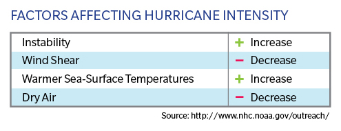
The results also carry considerable uncertainty, in part a result of hurricane rarity and the small number of major hurricanes in particular. There are also several factors that interact with one another to determine hurricane intensity such as sea-surface temperature, wind shear, instability and dry air (see the table below). Hurricanes can experience higher levels of disruptive wind shear while turning to the north, causing them to weaken. Many hurricanes also draw in dry air from the U.S. mainland on their approach, again with disruptive effects. These factors interact in a complex way and it is well known in the research and forecasting communities that there is much to learn on the question of hurricane intensity forecasting.
Meanwhile, the track findings of the Kossin study are consistent with an earlier effort by Wang et al., (4) which finds that in years with a large Atlantic Warm Pool (warm sea-surface temperatures in large areas of the tropics) hurricane activity in the basin increases, as one might expect. The paper also finds that the origin of hurricanes tends to shift to the east in these years, and also allows hurricanes to turn to the north before affecting the U.S. mainland. One example of such a season is 2010 - a very active period in the basin, but without any U.S. landfalls, thanks to steering currents in play during that year. The proportion of hurricanes in the basin that make U.S. landfall is highly volatile from year to year and history reminds us that impactful hurricanes can occur even in years with relatively quiet activity.
U.S. hurricane landfall data is considered in the scientific community to be reliable from 1900 onwards. Each landfall in the record implicitly accounts for the origin, steering currents, track and intensity factors. The longer record allows conclusions of greater statistical confidence than use of smaller windows of time, making use of the long term record a necessity given the rarity and volatility of these events. This is one reason why the catastrophe model vendors calibrate their models to the longer period of record, and also a reason why the state of Florida mandates the use of this record for catastrophe model use. While catastrophe models certainly have their challenges, this is one point of confidence to work with.
Note:
1. Conditions That Form More Hurricanes Also Protect U.S., Study Finds. New York Times, January 4, 2017.
2. Kossin, J.P., 2016: Hurricane intensification along United States coast suppressed during active hurricane periods. Nature. doi: 10.1038/nature20783
3. Hart, R.E., Chavas, D.R., Guishard, M.P., 2016: The arbitrary definition of the current Atlantic major hurricane landfall drought. Bulletin of the American Meteorological Society. doi: 10.1175/BAMS-D-15-00185.1.
4. Wang, C., Liu, H., Lee. S., Atlas, R., 2011: Impact of the Atlantic warm pool on United States landfalling hurricanes. Geophysical Research Letters, 38, L19702.
