

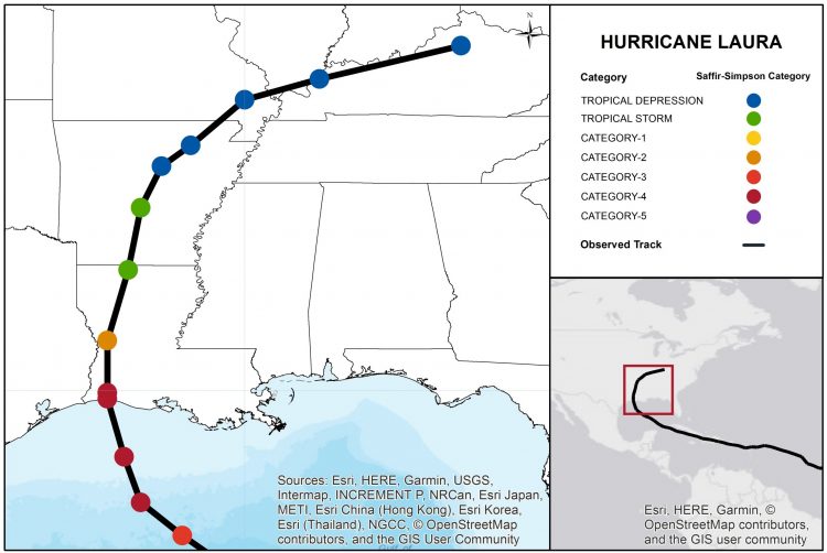
Hurricane Laura made landfall around 1 AM CDT Thursday, August 27 as a high-end category-4 hurricane, with maximum sustained winds of 150 mph. The storm moved ashore near Cameron, Louisiana after a period of rapid intensification, tying for the fifth strongest landfalling continental US hurricane on record. Severe wind damage has been reported to property and infrastructure in much of southwest Louisiana, with Lake Charles, LA damage especially severe.
The Hurricane Laura CAT-i bulletin comprises the following sections:
- Insured Loss Estimates
- Regional Impacts
- Notable Impacts by Sector
- Key Dates in the Timeline of Hurricane Laura
- Physical Discussion of Hurricane Laura accompanied by Peak Meteorological Statistics
Insured Loss Estimates
As of Monday, August 31, the following companies have issued insured loss estimates in association with Hurricane Laura, according to media reports (losses in USD).
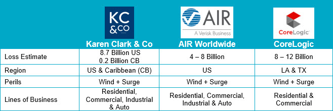
Insured loss estimates (USD). Sources: AIR Worldwide, CoreLogic, Karen Clark & Co.
Regional Impacts
United States
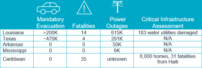
Nearly half of the fatalities were the result of carbon monoxide poisoning. The Red Cross estimates that around 8,000 homes may have been destroyed. 9,000 citizens are sheltering in hotels in Louisiana while as many as 8,000 are in Texas hotels. Nearly 6,240 members of the Louisiana National Guard are supporting recovery efforts, supplying 893,000 bottles of water, 473,000 meals, more than 36,000 bags of ice and about 14,000 tarps.
Louisiana
Impacts in southwest Louisiana have been especially severe as winds of a category-4 hurricane and seawater inundation due to storm surge have rendered significant impacts to numerous properties and infrastructure. Roads are impassable in coastal areas of Cameron Parish due to debris left by receding floodwaters. At South Cameron High School in Creole, considerable roof damage has been reported. A barge also has tilted on its side along the water. Variable property damage has been reported to several hospitals in Calcasieu Parish and one in Cameron Parish. Critical patients were evacuated to other facilities because of water and power concerns. Other hospitals are operating on intermittent generator power. Significant wind damage was also reported in Monroe, Lafayette, Starks and Vinton. Calcasieu School Board officials said 97 percent of their 70 sites and facilities have substantial damage. Schools have been closed in Calcasieu and in Cameron parishes until further notice. Flooding was reported across much of Natchitoches Parish, between Shreveport and Alexandria. University underpass in Lafayette was impassable due to rising water. At least 183 water systems have shut down, and more than 180,000 people are without running water.
Lake Charles, LA
The city of Lake Charles, LA was the largest population center in the direct path of category-4 impacts from Hurricane Laura with a population of nearly 80,000 people. Widespread and severe wind damage was reported to property and infrastructure in Lake Charles. Post-event footage indicates a TV tower collapsed and nearly 500 power transmission towers are down across the city. Many power poles were also snapped at their base. Power restoration efforts could take at least four weeks, according to reports. Downtown high-rise structures had shattered windows. Commercial structures were also severely affected, with initial evidence of higher damage for older structures or those made of unreinforced masonry. Significant damage to residential structures has also been reported, including severe damage to roofs and walls. Caribbean While maximum sustained winds remained at tropical storm levels, below 74 mph in the Caribbean, the track of Laura over the Greater Antilles brought a range of other meaningful impacts. Heavy rainfall and resulting flooding affected portions of Puerto Rico, Hispaniola and Cuba, with particularly severe impacts in Haiti. Tropical Storm conditions also affected portions of these areas. Recovery efforts are underway to repair downed power poles and downed trees along with some roof damage. Severe flooding and landslides affected Haiti where at least 31 fatalities have been reported by media. Over 6,000 homes have flooded. Severe flooding was reported in the Dominican Republic where at least four fatalities were reported by media. Landslides and flooded roads were also reported in Jamaica.
Notable Impacts by Sector

Personnel were evacuated from 299 oil and gas production platforms in the Gulf of Mexico, representing 46.5 percent of the 643 manned platforms. 84.3 percent of oil production and 60.9 percent of natural gas production for the Gulf of Mexico was shut-in in advance of Hurricane Laura. As of midday Monday August 31, 122 facilities were reoccupied.
![]()
Shelter in place orders were issued for residents in the communities of Westlake, Moss Bluff and Sulphur, LA in a 1-mile perimeter around a chemical fire from the BioLab plant. The fire is thought to have commenced due to a chlorine leak from the plant which produces cleaners, antifreeze and other chemical products.
The Texas and southwestern Louisiana coastline is epicenter of oil and gas exports from the United States. Reports of nearly a million barrels per day of crude exports reduced in US Gulf Coast terminals and ports.
Shipments of liquefied natural gas (LNG) fell to the lowest levels in 18 months due to disruptions at LNG facilities in Sabine Pass (Cheniere Energy) and Cameron, LA (Sempra Energy) terminals. Initial reports suggest a third LNG facility being built by Venture Global at Calcasieu Pass has sustained minimal damage.
![]()
Interstate 10 was closed from Lafayette, LA west to the Texas state line. A casino boat broke free from moorings during the height of the storm in Lake Charles, LA which struck a bridge, now being examined for any infrastructure damage.
Union Pacific reports heavy damage occurred to its rail network in the vicinity of Lake Charles, LA. The most significant impact to rail service is from Longview, TX to Alexandria, LA and on to Houston, TX.
![]()
Cotton crops were most susceptible to damage from Hurricane Laura due to portions of the cotton belt being in open boll stage. Prior to the landfall of Laura, 40% of Louisiana and 23% of Arkansas cotton crop were in open boll stage. Strong winds can dislodge cotton bolls from the plant as well as suffer quality declines due to excessive rainfall. Secondarily, soybean plants also experienced some lodging of pods but overall damage appears less than for cotton. Early reports from the University of Arkansas Agriculture Extension indicates minimal damage to rice. Impact to livestock initially appears to be minimal. Over 500 heads of cattle in far southwestern Louisiana are reported lost due to storm surge impacts.
![]()
The Entergy transmission system suffered extensive damage, including 221 transmission lines, 280 substations, 3,848 poles, 1,889 transformers and 6,285 spans of wire. 29,000 lineworkers from 29 states, Washington DC and Canada are in the Gulf Coast region to help restore power.
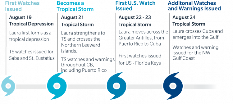
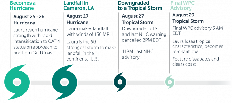
Key Dates in Timeline of Hurricane Laura
Physical Discussion
Looking back at the progression of Hurricane Laura from formation over the deep tropical Atlantic to landfall in Louisiana, three key meteorological aspects are noteworthy to highlight: enduring the mountainous Caribbean islands intact, the rapid intensification across the Gulf of Mexico, and a lack of any decay of the storm through landfall.
- Enduring the mountainous Caribbean islands: After being declared a tropical depression 1,000 miles east of the Northern Leeward Islands on August 19 and upgraded to a tropical storm on August 21, the forecast called for the possibility of significant interaction with the mountainous islands of Hispaniola and Cuba as Laura tracked across the Greater Antilles. As history has shown in many tropical systems in the northern Caribbean, significant island interaction can result in a decay of the storm without further development. For Laura, the tropical storm retained remarkable organization despite the mountains of the Dominican Republic, Haiti and Cuba during August 22 and 23. With increasing confidence that Laura would remain intact into the Gulf of Mexico, attention turned towards US Gulf Coast landfall implications becoming increasingly likely
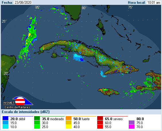
Radar loop of TS Laura passing over Cuba on Aug 24. Source: Instituto de Meteorologica, Inicio.
- Rapid intensification (RI) in the Gulf of Mexico: By August 24, Laura was situated just south of Central Cuba as highlighted above. NHC forecasts at the time were beginning to show the possibility of a major hurricane landfall along the west-central Gulf of Mexico US coastline. Laura strengthened into hurricane status Tuesday morning, August 25, following its emergence into the Gulf of Mexico from Cuba. Weather forecasts honed in on a landfall along the Texas/Louisiana border with increasing likelihood of rapid intensification as the environment across the Gulf of Mexico featured low wind shear and above average sea surface temperatures. Hurricane Laura strengthened to major hurricane status 24 hours later on August 26, undergoing RI of 45 mph in 24 hours. Laura follows a number of storms to accomplish this feat in the last several years (Hanna 2020, Michael 2018, Harvey 2017) and other noteworthy Gulf Coast landfalls such as Katrina and Rita (2005) and even Camille (1969). To the degree RI characteristics in the Gulf of Mexico are changing as a result of a changing climate is an area of intriguing and active research
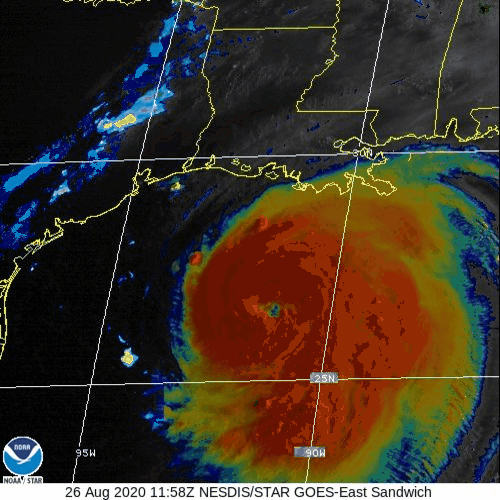
VIS/IR Sandwich Satellite Loop. Combines the cloud top detail of the visible channel, with the temperature information of the IR. Note the emerging eye and the broad thunderstorm activity in the cloud tops Source: CIMSS.
- Hurricane Laura does not weaken before landfall: Laura made landfall in Cameron, Louisiana, early in the morning on August 27 as a high-end category-4 hurricane, packing maximum sustained winds of 150 mph. Many tropical cyclones will start to lose intensity before the eyewall of the hurricane crosses land as the friction of land starts to disrupt the circulation of the storm. However, Laura did not lose any intensity prior to landfall, and now ties five other hurricanes as the fifth strongest US continental US landfall since 1851, only behind the four category 5 landfalls of Labor Day 1935, Camille, Andrew and Michael.
Peak Meteorological Statistic
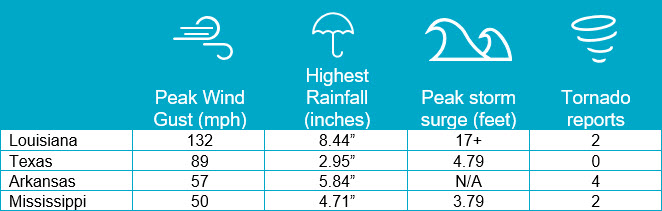
Note: Storm surge elevation are all above NAVD88 datum. Highest rainfall reported by AWOS/AFOS weather stations in a 72 hour period. Other noteworthy maximum sustained / peak wind gust measurements (mph) across Louisiana include Cameron, LA (101, gust to 117), Calcasieu Pass (gust 93), Lake Charles (98, gust to 132), Sabine Pass (74, gust to 90) and Alexandria (58, gust to 86). Source: NWS, NOAA, CERA, Guy Carpenter.
Sources: Reuters, The Weather Channel, Associated Press, BBC, CoreLogic, AIR-Worldwide, CoreLogic, Karen Clark & Co. U.S. National Hurricane Center, U.S. National Weather Service, Insurance Journal, Energy News Room, Wall Street Journal, Bureau of Safety and Environmental Enforcement, Freight Waves.