

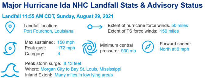
Hurricane Ida made landfall at 11:55 AM CDT Sunday, August 30 as a high-end category-4 hurricane, with maximum sustained winds of 150 mph. The storm moved ashore near Port Fourchon, Louisiana after a period of rapid intensification, tying for the fifth strongest landfalling continental US hurricane on record with Hurricane Laura of 2020, among three other hurricanes. Severe wind and large scale flood damage has been reported to property and infrastructure in much of southeast Louisiana, including significant damage in New Orleans, Louisiana. In addition, Ida has caused widespread damage across the Mid-Atlantic and Northeast US. Additional impacts outside the Gulf Coast will be discussed in a second Post Event Report on Ida to be issued the week of September 6 after conclusion of the event.
The Hurricane Ida post-event report comprises the following sections:
- Insured Loss Estimates
- Regional Impacts
- Notable Impacts by Sector
- Implications for the Insurance Industry
- Key Dates in the Timeline of Hurricane Laura
- Physical Discussion of Hurricane Laura
- Peak Meteorological Statistics
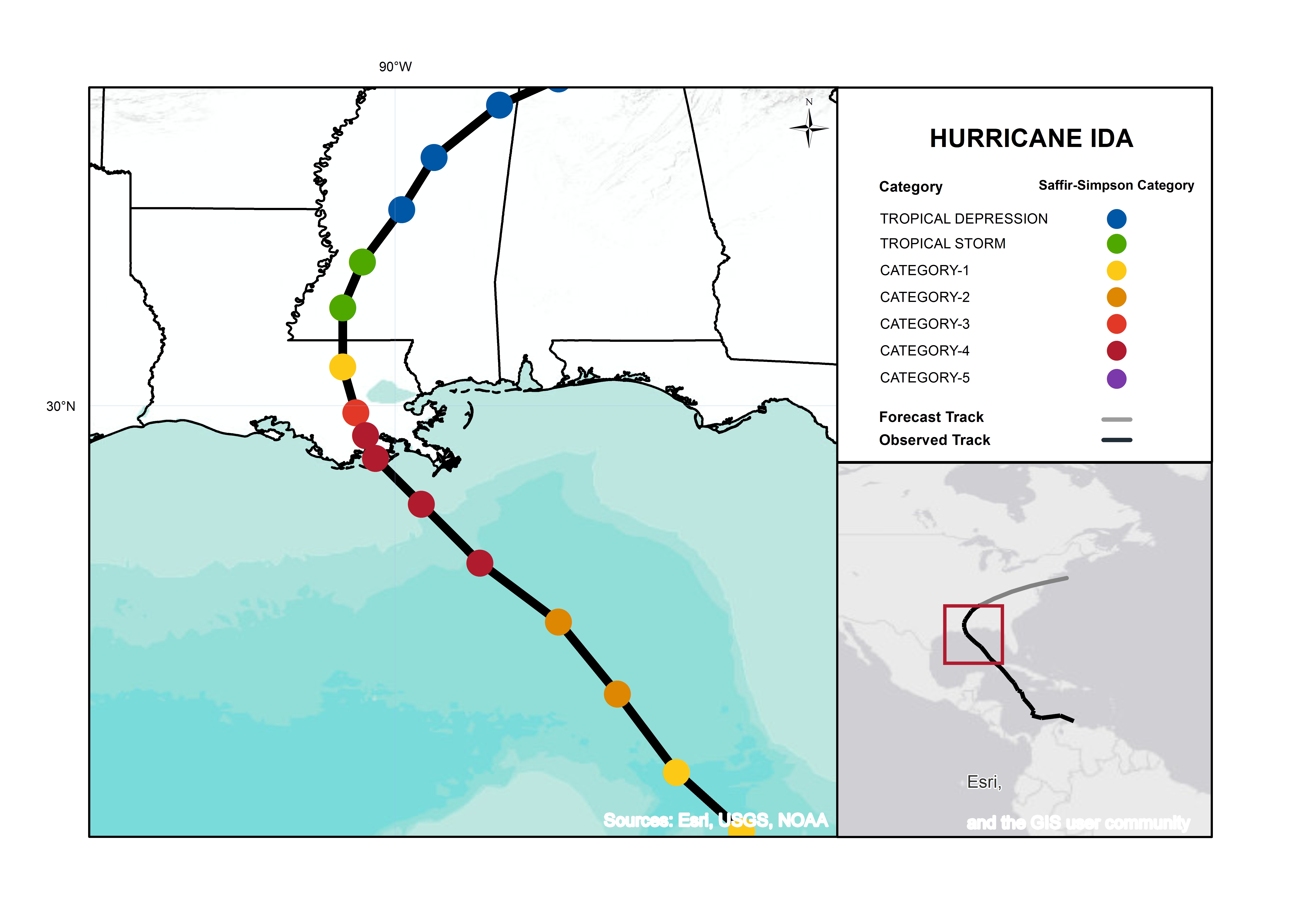
Hurricane Ida track and intensity at Gulf Coast Landfall. Source: NHC/NOAA.
Regional Insured Loss Estimates
As of Thursday, September 2, the following companies have issued insured loss estimates in association with Hurricane Ida, according to media reports (losses in USD).
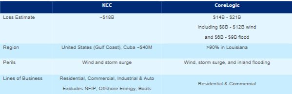
Source: Karen Clark & Company (KCC), Corelogic (EQE)
Regional Impacts
The full post event report provides a detailed assessment of impacts to regions exposed to the category-4 landfall of Hurricane Ida along the Gulf Coast. Hurricane Ida rendered significant damage across parts of southeastern Louisiana after making landfall as a category-4 storm on Sunday, August 29. More than 1 million homes and businesses were without power in Louisiana and Mississippi and at least six fatalities have been connected to Ida, with the number expected to climb as search and rescue efforts continue. Extreme and widespread flooding has been observed throughout portions of the Mid-Atlantic and Northeast, as well as significant tornadic activity as Ida moved through the region. Details on Ida’s post-tropical impacts will be addressed in a subsequent report from Guy Carpenter.
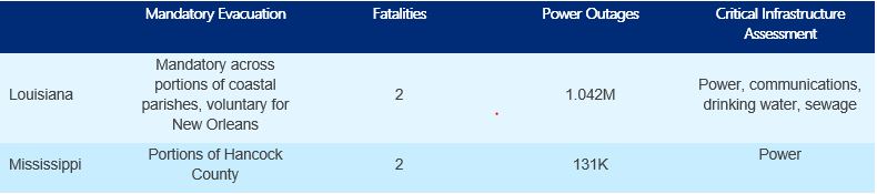
Source: AP News / Poweroutage.us
Notable Impacts By Sector
In addition to extensive damage to the Entergy transmission system, 96% of offshore oil production and 94% of offshore natural gas production were shut-in and at least nine refineries in Louisiana reduced production or shut-in operations in advance of Ida’s landfall. This accounts for 2.3 billion barrels per day of US refinery capacity, equating to 13% of the total US operable refinery capacity. The full post event report provides a detailed assessment of the energy shut downs, plus a discussion of supply chain, transportation and livestock and agricultural impacts.
Implications for the Insurance Industry
There are multiple long-term implications for the insurance sector as recovery after Hurricane Ida begins. The largest utility for the region, Entergy, indicates the catastrophic failure of the southeast Louisiana utility infrastructure will take weeks to months to fully recover. Additionally, the full post event report provides a detailed assessment of the success of the Hurricane Storm Surge Risk Reduction System, the complexity of wind vs. water claims, and the ongoing issue of escalating repair costs.
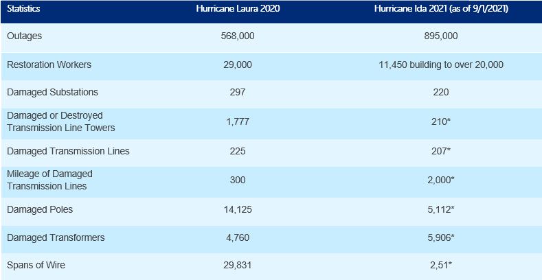
Source: Entergy Storm Center. Note: Estimates with asteriks traditionally grow larger as recovery efforts continue with 36% of assets inspected. The analysis highlights the efforts required to rebuild the grid in Hurricane Laura compared to the progress after Hurricane Ida as evaluation and restoration continues.
Key Dates of Hurricane Ida
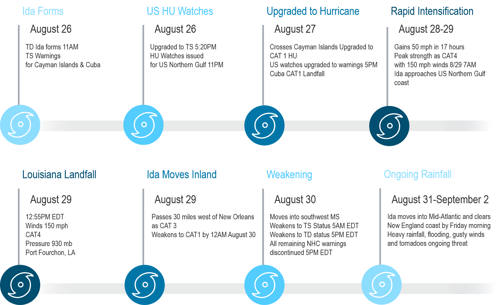
Physical Discussion of Hurricane Ida
Looking back at the progression of Hurricane Ida from formation over the western Caribbean to landfall in Louisiana 73 hours later, several key aspects are noteworthy to highlight:
- Rapid intensification over the Gulf of Mexico
- Accuracy of the National Hurricane Center forecast and evacuation timeliness
- Storm surge impacts relative to Hurricane Katrina
- Widespread coastal and inland flooding due to excessive rainfall
A detailed discussion of the meteorological factors influencing Hurricane Ida's Gulf Coast landfall (wind, storm surge and rainfall) can be found in the full post event report.
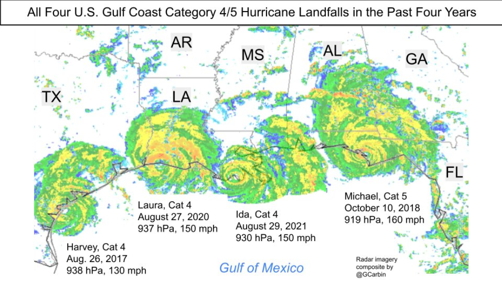
Source: Greg Carbin, Weather Prediction Center / NOAA
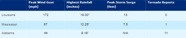
Source: For the peak meteorological statistics, storm surge elevation are all above NAVD88 datum . Highest rainfall reported by local media in a 48-hour period. Other noteworthy peak wind gust measurements (mph) across Louisiana include Leeville (153), Grand Isle (146), Dulac (138), Southwest Pass (128), Golden Meadow (125), New Orleans (110).
Communications Schedule
Due to the multiple facets of the ongoing impacts from Hurricane Ida's transit across the United States, the schedule of CAT Resource Center updates include:
- Today's Post Event Report on Ida covers the landfall and southern U.S. impacts
- A Live Event Report is also being issued today to cover the latest flood and tornado activity associated with Ida in the Mid-Atlantic.
- Part 2 of the Post Event Report on Ida, assessing damage from the severe weather in the Mid-Atlantic, is planned for the middle of next week.
Report Sources: Reuters, Everstream Analytics, PortFourchon.com, PortNOLA.com, The Washington Post, The Weather Channel, Associated Press, BBC, PowerOutage.US, CoreLogic, Karen Clark & Co., U.S. National Hurricane Center, U.S. National Weather Service, Insurance Journal, Energy News Room, Wall Street Journal, Bureau of Safety and Environmental Enforcement, Freight Waves